You are here: Home > Network List > TX - Texas Seismological Network Stations List
> Station SN02 Snyder 2 > Earthquake Result Viewer
SN02 Snyder 2 - Earthquake Result Viewer
| Earthquake location: |
Kamchatka Peninsula, Russia |
| Earthquake latitude/longitude: |
55.9/158.5 |
| Earthquake time(UTC): |
2020/09/15 (259) 03:41:28 GMT |
| Earthquake Depth: |
344 km |
| Earthquake Magnitude: |
6.4 Mww |
| Earthquake Catalog/Contributor: |
NEIC PDE/us |
|
| Network: |
TX Texas Seismological Network |
| Station: |
SN02 Snyder 2 |
| Lat/Lon: |
32.86 N/100.91 W |
| Elevation: |
748 m |
|
| Distance: |
69.0 deg |
| Az: |
62.404 deg |
| Baz: |
323.653 deg |
| Ray Param: |
0.05490891 |
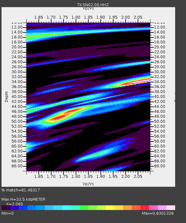
| Estimated Moho Depth: |
33.5 km |
| Estimated Crust Vp/Vs: |
2.07 |
| Assumed Crust Vp: |
6.426 km/s |
| Estimated Crust Vs: |
3.112 km/s |
| Estimated Crust Poisson's Ratio: |
0.35 |
|
| Radial Match: |
81.46317 % |
| Radial Bump: |
297 |
| Transverse Match: |
63.082664 % |
| Transverse Bump: |
400 |
| SOD ConfigId: |
22732711 |
| Insert Time: |
2020-09-29 04:12:29.434 +0000 |
| GWidth: |
2.5 |
| Max Bumps: |
400 |
| Tol: |
0.001 |
|

Signal To Noise
| Channel | StoN | STA | LTA |
| TX:SN02:00:HHZ:20200915T03:51:25.93003Z | 25.70262 | 2.0018078E-6 | 7.788341E-8 |
| TX:SN02:00:HH1:20200915T03:51:25.93003Z | 6.906158 | 8.31023E-7 | 1.2033072E-7 |
| TX:SN02:00:HH2:20200915T03:51:25.93003Z | 3.5953841 | 4.358564E-7 | 1.2122666E-7 |
| Arrivals |
| Ps | 5.7 SECOND |
| PpPs | 15 SECOND |
| PsPs/PpSs | 21 SECOND |


