You are here: Home > Network List > UO - University of Oregon Regional Network Stations List
> Station PIN Pine Mt., Oregon (U0 BB CREST SMO) > Earthquake Result Viewer
PIN Pine Mt., Oregon (U0 BB CREST SMO) - Earthquake Result Viewer
| Earthquake location: |
Peru-Brazil Border Region |
| Earthquake latitude/longitude: |
-7.6/-74.4 |
| Earthquake time(UTC): |
2008/08/26 (239) 21:00:36 GMT |
| Earthquake Depth: |
154 km |
| Earthquake Magnitude: |
6.0 MB, 6.4 MW, 6.4 MW |
| Earthquake Catalog/Contributor: |
WHDF/NEIC |
|
| Network: |
UO University of Oregon Regional Network |
| Station: |
PIN Pine Mt., Oregon (U0 BB CREST SMO) |
| Lat/Lon: |
43.81 N/120.87 W |
| Elevation: |
1865 m |
|
| Distance: |
66.2 deg |
| Az: |
324.99 deg |
| Baz: |
128.229 deg |
| Ray Param: |
0.057305798 |
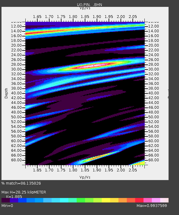
| Estimated Moho Depth: |
28.25 km |
| Estimated Crust Vp/Vs: |
1.88 |
| Assumed Crust Vp: |
6.597 km/s |
| Estimated Crust Vs: |
3.5 km/s |
| Estimated Crust Poisson's Ratio: |
0.30 |
|
| Radial Match: |
86.135826 % |
| Radial Bump: |
400 |
| Transverse Match: |
87.19504 % |
| Transverse Bump: |
400 |
| SOD ConfigId: |
2504 |
| Insert Time: |
2010-03-09 01:18:06.987 +0000 |
| GWidth: |
2.5 |
| Max Bumps: |
400 |
| Tol: |
0.001 |
|

Signal To Noise
| Channel | StoN | STA | LTA |
| UO:PIN: :BHN:20080826T21:10:37.250015Z | 19.633467 | 1.520834E-6 | 7.746131E-8 |
| UO:PIN: :BHE:20080826T21:10:37.250015Z | 2.6450598 | 4.515113E-7 | 1.7069985E-7 |
| UO:PIN: :BHZ:20080826T21:10:37.250015Z | 1.8656101 | 4.062333E-7 | 2.1774824E-7 |
| Arrivals |
| Ps | 3.9 SECOND |
| PpPs | 12 SECOND |
| PsPs/PpSs | 16 SECOND |


