You are here: Home > Network List > US - United States National Seismic Network Stations List
> Station WRAK Wrangell Island, Southeastern Alaska, Alaska, USA > Earthquake Result Viewer
WRAK Wrangell Island, Southeastern Alaska, Alaska, USA - Earthquake Result Viewer
| Earthquake location: |
Kamchatka Peninsula, Russia |
| Earthquake latitude/longitude: |
55.9/158.5 |
| Earthquake time(UTC): |
2020/09/15 (259) 03:41:28 GMT |
| Earthquake Depth: |
344 km |
| Earthquake Magnitude: |
6.4 Mww |
| Earthquake Catalog/Contributor: |
NEIC PDE/us |
|
| Network: |
US United States National Seismic Network |
| Station: |
WRAK Wrangell Island, Southeastern Alaska, Alaska, USA |
| Lat/Lon: |
56.42 N/132.35 W |
| Elevation: |
81 m |
|
| Distance: |
37.0 deg |
| Az: |
59.596 deg |
| Baz: |
299.125 deg |
| Ray Param: |
0.07491932 |
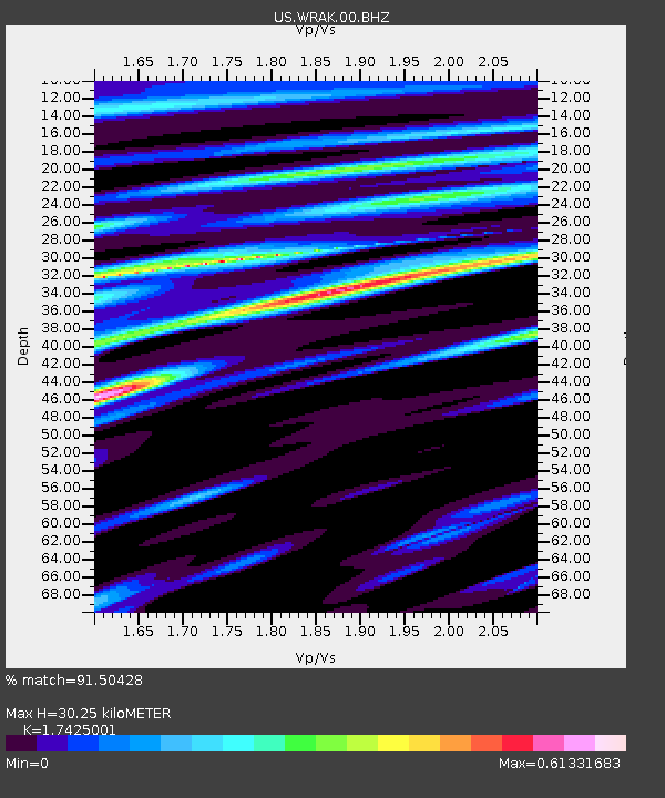
| Estimated Moho Depth: |
30.25 km |
| Estimated Crust Vp/Vs: |
1.74 |
| Assumed Crust Vp: |
6.597 km/s |
| Estimated Crust Vs: |
3.786 km/s |
| Estimated Crust Poisson's Ratio: |
0.25 |
|
| Radial Match: |
91.50428 % |
| Radial Bump: |
354 |
| Transverse Match: |
71.10147 % |
| Transverse Bump: |
400 |
| SOD ConfigId: |
22732711 |
| Insert Time: |
2020-09-29 04:14:55.108 +0000 |
| GWidth: |
2.5 |
| Max Bumps: |
400 |
| Tol: |
0.001 |
|
Signal To Noise
| Channel | StoN | STA | LTA |
| US:WRAK:00:BHZ:20200915T03:47:35.699988Z | 33.686066 | 3.109503E-6 | 9.2308284E-8 |
| US:WRAK:00:BH1:20200915T03:47:35.699988Z | 14.892521 | 1.2292617E-6 | 8.2542215E-8 |
| US:WRAK:00:BH2:20200915T03:47:35.699988Z | 18.90373 | 1.6777159E-6 | 8.875052E-8 |
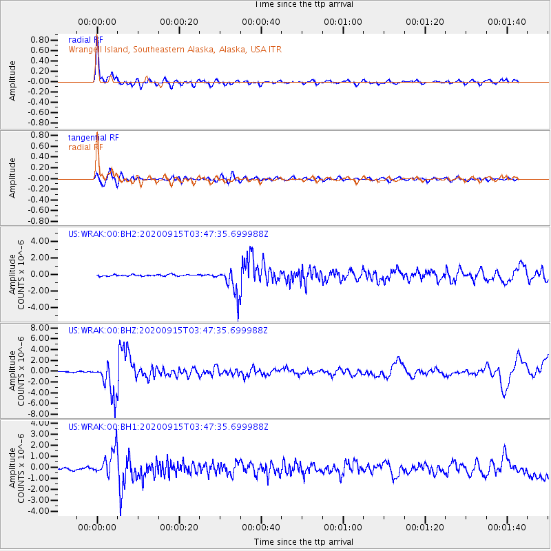
| Arrivals |
| Ps | 3.7 SECOND |
| PpPs | 12 SECOND |
| PsPs/PpSs | 15 SECOND |


