You are here: Home > Network List > UU - University of Utah Regional Network Stations List
> Station SVWY Solvay Mine, WY, USA > Earthquake Result Viewer
SVWY Solvay Mine, WY, USA - Earthquake Result Viewer
| Earthquake location: |
Kamchatka Peninsula, Russia |
| Earthquake latitude/longitude: |
55.9/158.5 |
| Earthquake time(UTC): |
2020/09/15 (259) 03:41:28 GMT |
| Earthquake Depth: |
344 km |
| Earthquake Magnitude: |
6.4 Mww |
| Earthquake Catalog/Contributor: |
NEIC PDE/us |
|
| Network: |
UU University of Utah Regional Network |
| Station: |
SVWY Solvay Mine, WY, USA |
| Lat/Lon: |
41.45 N/109.86 W |
| Elevation: |
1950 m |
|
| Distance: |
57.8 deg |
| Az: |
62.605 deg |
| Baz: |
318.337 deg |
| Ray Param: |
0.06201299 |
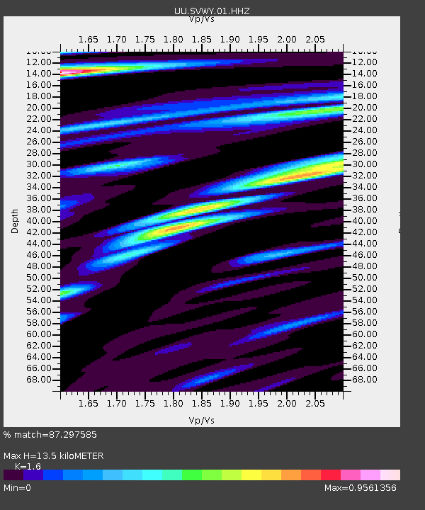
| Estimated Moho Depth: |
13.5 km |
| Estimated Crust Vp/Vs: |
1.60 |
| Assumed Crust Vp: |
6.207 km/s |
| Estimated Crust Vs: |
3.879 km/s |
| Estimated Crust Poisson's Ratio: |
0.18 |
|
| Radial Match: |
87.297585 % |
| Radial Bump: |
400 |
| Transverse Match: |
65.46719 % |
| Transverse Bump: |
400 |
| SOD ConfigId: |
22732711 |
| Insert Time: |
2020-09-29 04:15:40.617 +0000 |
| GWidth: |
2.5 |
| Max Bumps: |
400 |
| Tol: |
0.001 |
|

Signal To Noise
| Channel | StoN | STA | LTA |
| UU:SVWY:01:HHZ:20200915T03:50:13.709998Z | 26.467909 | 1.1366788E-7 | 4.2945545E-9 |
| UU:SVWY:01:HHN:20200915T03:50:13.709998Z | 9.426915 | 3.298463E-8 | 3.4989844E-9 |
| UU:SVWY:01:HHE:20200915T03:50:13.709998Z | 8.492827 | 2.8307245E-8 | 3.3330765E-9 |
| Arrivals |
| Ps | 1.4 SECOND |
| PpPs | 5.4 SECOND |
| PsPs/PpSs | 6.8 SECOND |


