You are here: Home > Network List > UU - University of Utah Regional Network Stations List
> Station SZCU Shurtz Canyon, UT, USA > Earthquake Result Viewer
SZCU Shurtz Canyon, UT, USA - Earthquake Result Viewer
| Earthquake location: |
Kamchatka Peninsula, Russia |
| Earthquake latitude/longitude: |
55.9/158.5 |
| Earthquake time(UTC): |
2020/09/15 (259) 03:41:28 GMT |
| Earthquake Depth: |
344 km |
| Earthquake Magnitude: |
6.4 Mww |
| Earthquake Catalog/Contributor: |
NEIC PDE/us |
|
| Network: |
UU University of Utah Regional Network |
| Station: |
SZCU Shurtz Canyon, UT, USA |
| Lat/Lon: |
37.60 N/113.09 W |
| Elevation: |
2026 m |
|
| Distance: |
59.1 deg |
| Az: |
67.786 deg |
| Baz: |
319.006 deg |
| Ray Param: |
0.061226692 |
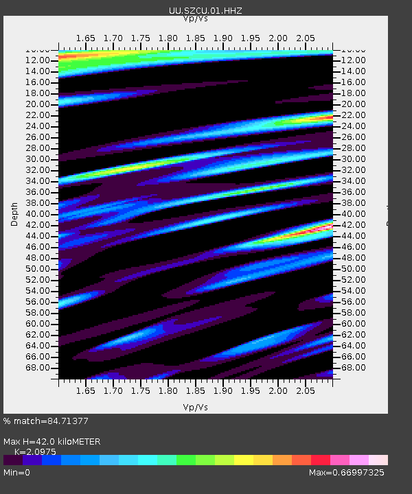
| Estimated Moho Depth: |
42.0 km |
| Estimated Crust Vp/Vs: |
2.10 |
| Assumed Crust Vp: |
6.194 km/s |
| Estimated Crust Vs: |
2.953 km/s |
| Estimated Crust Poisson's Ratio: |
0.35 |
|
| Radial Match: |
84.71377 % |
| Radial Bump: |
400 |
| Transverse Match: |
69.63254 % |
| Transverse Bump: |
400 |
| SOD ConfigId: |
22732711 |
| Insert Time: |
2020-09-29 04:15:42.258 +0000 |
| GWidth: |
2.5 |
| Max Bumps: |
400 |
| Tol: |
0.001 |
|

Signal To Noise
| Channel | StoN | STA | LTA |
| UU:SZCU:01:HHZ:20200915T03:50:22.209998Z | 13.717014 | 4.8886868E-8 | 3.5639582E-9 |
| UU:SZCU:01:HHN:20200915T03:50:22.209998Z | 4.9309216 | 1.3422602E-8 | 2.7221285E-9 |
| UU:SZCU:01:HHE:20200915T03:50:22.209998Z | 6.604342 | 1.4004397E-8 | 2.1204833E-9 |
| Arrivals |
| Ps | 7.7 SECOND |
| PpPs | 20 SECOND |
| PsPs/PpSs | 28 SECOND |


