You are here: Home > Network List > GS - US Geological Survey Networks Stations List
> Station KAN08 Pence Farm, Harper, KS, USA > Earthquake Result Viewer
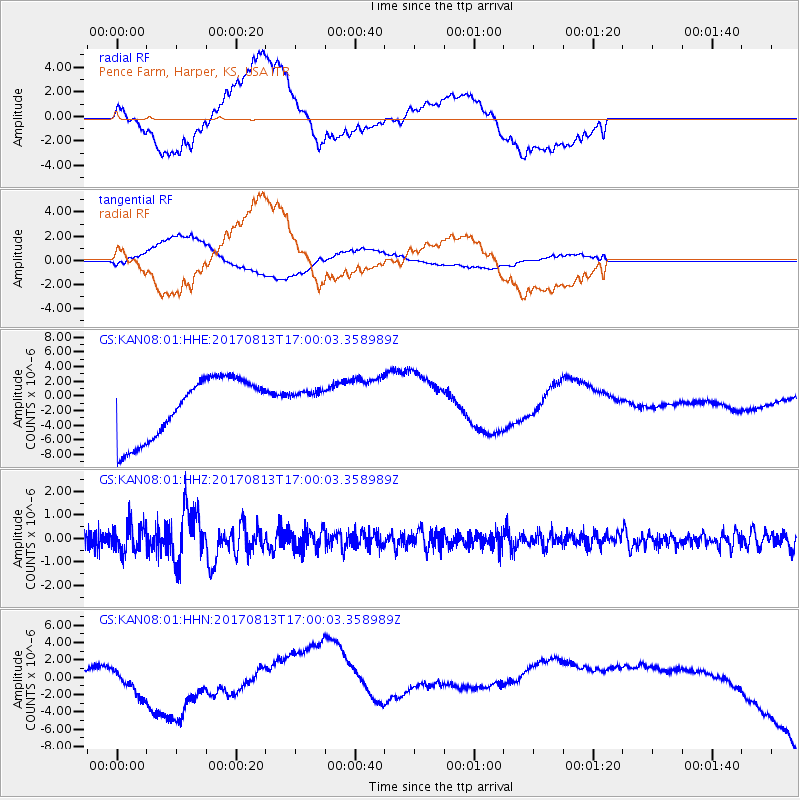
KAN08 Pence Farm, Harper, KS, USA - Earthquake Result Viewer
*The percent match for this event was below the threshold and hence no stack was calculated.
| Earthquake location: |
Central Peru |
| Earthquake latitude/longitude: |
-10.7/-74.6 |
| Earthquake time(UTC): |
2017/08/13 (225) 16:51:22 GMT |
| Earthquake Depth: |
21 km |
| Earthquake Magnitude: |
5.6 mb |
| Earthquake Catalog/Contributor: |
NEIC PDE/us |
|
| Network: |
GS US Geological Survey Networks |
| Station: |
KAN08 Pence Farm, Harper, KS, USA |
| Lat/Lon: |
37.23 N/97.97 W |
| Elevation: |
375 m |
|
| Distance: |
52.5 deg |
| Az: |
336.444 deg |
| Baz: |
150.523 deg |
| Ray Param: |
$rayparam |
*The percent match for this event was below the threshold and hence was not used in the summary stack. |
|
| Radial Match: |
23.78711 % |
| Radial Bump: |
400 |
| Transverse Match: |
40.013935 % |
| Transverse Bump: |
400 |
| SOD ConfigId: |
2140511 |
| Insert Time: |
2017-08-27 08:50:15.616 +0000 |
| GWidth: |
2.5 |
| Max Bumps: |
400 |
| Tol: |
0.001 |
|
Signal To Noise
| Channel | StoN | STA | LTA |
| GS:KAN08:01:HHZ:20170813T17:00:03.358989Z | 1.9558904 | 5.8419306E-7 | 2.9868394E-7 |
| GS:KAN08:01:HHN:20170813T17:00:03.358989Z | 0.6141827 | 2.078348E-6 | 3.3839246E-6 |
| GS:KAN08:01:HHE:20170813T17:00:03.358989Z | 0.47334436 | 1.9627957E-6 | 4.146655E-6 |
| Arrivals |
| Ps | |
| PpPs | |
| PsPs/PpSs | |


