You are here: Home > Network List > UO - University of Oregon Regional Network Stations List
> Station PIN Pine Mt., Oregon (U0 broad-band > Earthquake Result Viewer
PIN Pine Mt., Oregon (U0 broad-band - Earthquake Result Viewer
| Earthquake location: |
Northeastern China |
| Earthquake latitude/longitude: |
44.8/129.9 |
| Earthquake time(UTC): |
2002/09/15 (258) 08:39:32 GMT |
| Earthquake Depth: |
586 km |
| Earthquake Magnitude: |
5.8 MB, 6.4 MW, 6.4 MW |
| Earthquake Catalog/Contributor: |
WHDF/NEIC |
|
| Network: |
UO University of Oregon Regional Network |
| Station: |
PIN Pine Mt., Oregon (U0 broad-band |
| Lat/Lon: |
43.81 N/120.87 W |
| Elevation: |
1860 m |
|
| Distance: |
71.6 deg |
| Az: |
46.087 deg |
| Baz: |
314.924 deg |
| Ray Param: |
0.05221294 |
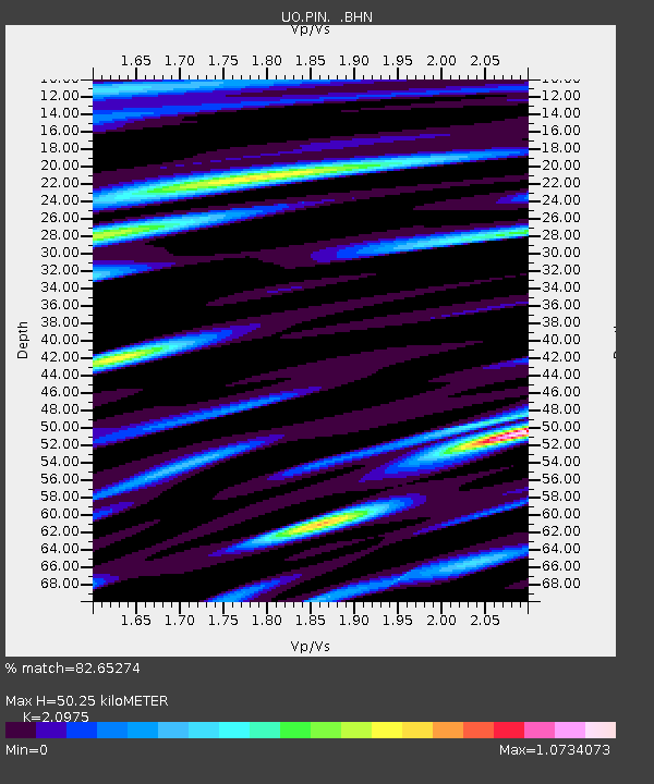
| Estimated Moho Depth: |
50.25 km |
| Estimated Crust Vp/Vs: |
2.10 |
| Assumed Crust Vp: |
6.597 km/s |
| Estimated Crust Vs: |
3.145 km/s |
| Estimated Crust Poisson's Ratio: |
0.35 |
|
| Radial Match: |
82.65274 % |
| Radial Bump: |
400 |
| Transverse Match: |
75.31479 % |
| Transverse Bump: |
400 |
| SOD ConfigId: |
4714 |
| Insert Time: |
2010-03-09 01:18:28.160 +0000 |
| GWidth: |
2.5 |
| Max Bumps: |
400 |
| Tol: |
0.001 |
|

Signal To Noise
| Channel | StoN | STA | LTA |
| UO:PIN: :BHN:20020915T08:49:24.804004Z | 3.2026587 | 388.47092 | 121.29639 |
| UO:PIN: :BHE:20020915T08:49:24.804004Z | 2.9711838 | 445.12207 | 149.81303 |
| UO:PIN: :BHZ:20020915T08:49:24.804004Z | 18.328842 | 1577.965 | 86.0919 |
| Arrivals |
| Ps | 8.6 SECOND |
| PpPs | 23 SECOND |
| PsPs/PpSs | 32 SECOND |


