You are here: Home > Network List > AV - Alaska Volcano Observatory Stations List
> Station TAPA Point Aries, Tanaga Volcano, Alaska > Earthquake Result Viewer
TAPA Point Aries, Tanaga Volcano, Alaska - Earthquake Result Viewer
| Earthquake location: |
Fiji Islands |
| Earthquake latitude/longitude: |
-15.1/179.9 |
| Earthquake time(UTC): |
2020/09/15 (259) 04:12:16 GMT |
| Earthquake Depth: |
10 km |
| Earthquake Magnitude: |
6.0 Mww |
| Earthquake Catalog/Contributor: |
NEIC PDE/us |
|
| Network: |
AV Alaska Volcano Observatory |
| Station: |
TAPA Point Aries, Tanaga Volcano, Alaska |
| Lat/Lon: |
51.81 N/177.81 W |
| Elevation: |
640 m |
|
| Distance: |
66.7 deg |
| Az: |
1.515 deg |
| Baz: |
182.358 deg |
| Ray Param: |
0.05747813 |
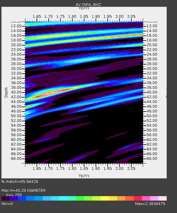
| Estimated Moho Depth: |
40.25 km |
| Estimated Crust Vp/Vs: |
1.71 |
| Assumed Crust Vp: |
5.88 km/s |
| Estimated Crust Vs: |
3.449 km/s |
| Estimated Crust Poisson's Ratio: |
0.24 |
|
| Radial Match: |
85.56426 % |
| Radial Bump: |
378 |
| Transverse Match: |
98.57435 % |
| Transverse Bump: |
118 |
| SOD ConfigId: |
22732711 |
| Insert Time: |
2020-09-29 04:22:57.291 +0000 |
| GWidth: |
2.5 |
| Max Bumps: |
400 |
| Tol: |
0.001 |
|
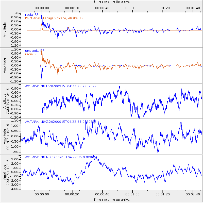
Signal To Noise
| Channel | StoN | STA | LTA |
| AV:TAPA: :BHZ:20200915T04:22:35.938982Z | 1.3209424 | 5.239647E-7 | 3.9665971E-7 |
| AV:TAPA: :BHN:20200915T04:22:35.938982Z | 0.73873466 | 8.443557E-7 | 1.1429756E-6 |
| AV:TAPA: :BHE:20200915T04:22:35.938982Z | 1.3053797 | 3.6729165E-7 | 2.8136768E-7 |
| Arrivals |
| Ps | 5.0 SECOND |
| PpPs | 18 SECOND |
| PsPs/PpSs | 23 SECOND |


