You are here: Home > Network List > AV - Alaska Volcano Observatory Stations List
> Station PLBL Mt. Peulik Volcano, Alaska > Earthquake Result Viewer
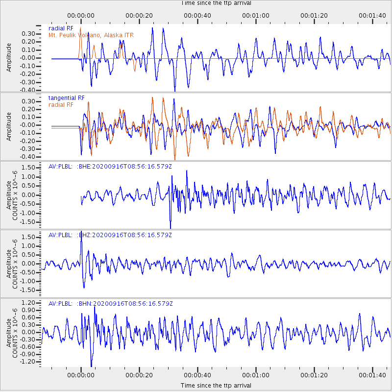
PLBL Mt. Peulik Volcano, Alaska - Earthquake Result Viewer
*The percent match for this event was below the threshold and hence no stack was calculated.
| Earthquake location: |
Southeast Of Loyalty Islands |
| Earthquake latitude/longitude: |
-22.3/171.5 |
| Earthquake time(UTC): |
2020/09/16 (260) 08:44:30 GMT |
| Earthquake Depth: |
119 km |
| Earthquake Magnitude: |
5.6 Mww |
| Earthquake Catalog/Contributor: |
NEIC PDE/us |
|
| Network: |
AV Alaska Volcano Observatory |
| Station: |
PLBL Mt. Peulik Volcano, Alaska |
| Lat/Lon: |
57.70 N/156.82 W |
| Elevation: |
461 m |
|
| Distance: |
84.0 deg |
| Az: |
16.471 deg |
| Baz: |
209.271 deg |
| Ray Param: |
$rayparam |
*The percent match for this event was below the threshold and hence was not used in the summary stack. |
|
| Radial Match: |
69.019196 % |
| Radial Bump: |
400 |
| Transverse Match: |
55.620567 % |
| Transverse Bump: |
400 |
| SOD ConfigId: |
22732711 |
| Insert Time: |
2020-09-30 08:48:35.314 +0000 |
| GWidth: |
2.5 |
| Max Bumps: |
400 |
| Tol: |
0.001 |
|
Signal To Noise
| Channel | StoN | STA | LTA |
| AV:PLBL: :BHZ:20200916T08:56:16.579Z | 3.0818362 | 7.530344E-7 | 2.44346E-7 |
| AV:PLBL: :BHN:20200916T08:56:16.579Z | 3.1945465 | 6.226247E-7 | 1.9490238E-7 |
| AV:PLBL: :BHE:20200916T08:56:16.579Z | 2.6603098 | 5.946165E-7 | 2.2351401E-7 |
| Arrivals |
| Ps | |
| PpPs | |
| PsPs/PpSs | |


