You are here: Home > Network List > AZ - ANZA Regional Network Stations List
> Station SMER AZ.SMER > Earthquake Result Viewer
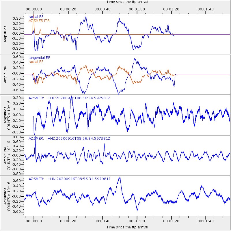
SMER AZ.SMER - Earthquake Result Viewer
*The percent match for this event was below the threshold and hence no stack was calculated.
| Earthquake location: |
Southeast Of Loyalty Islands |
| Earthquake latitude/longitude: |
-22.3/171.5 |
| Earthquake time(UTC): |
2020/09/16 (260) 08:44:30 GMT |
| Earthquake Depth: |
119 km |
| Earthquake Magnitude: |
5.6 Mww |
| Earthquake Catalog/Contributor: |
NEIC PDE/us |
|
| Network: |
AZ ANZA Regional Network |
| Station: |
SMER AZ.SMER |
| Lat/Lon: |
33.46 N/117.17 W |
| Elevation: |
355 m |
|
| Distance: |
87.7 deg |
| Az: |
52.434 deg |
| Baz: |
241.393 deg |
| Ray Param: |
$rayparam |
*The percent match for this event was below the threshold and hence was not used in the summary stack. |
|
| Radial Match: |
49.8458 % |
| Radial Bump: |
400 |
| Transverse Match: |
44.984676 % |
| Transverse Bump: |
400 |
| SOD ConfigId: |
22732711 |
| Insert Time: |
2020-09-30 08:49:12.616 +0000 |
| GWidth: |
2.5 |
| Max Bumps: |
400 |
| Tol: |
0.001 |
|
Signal To Noise
| Channel | StoN | STA | LTA |
| AZ:SMER: :HHZ:20200916T08:56:34.597981Z | 2.4148932 | 2.4330816E-7 | 1.0075318E-7 |
| AZ:SMER: :HHN:20200916T08:56:34.597981Z | 0.8846333 | 2.3336999E-7 | 2.6380422E-7 |
| AZ:SMER: :HHE:20200916T08:56:34.597981Z | 0.68035465 | 1.03648084E-7 | 1.523442E-7 |
| Arrivals |
| Ps | |
| PpPs | |
| PsPs/PpSs | |


