You are here: Home > Network List > AV - Alaska Volcano Observatory Stations List
> Station AKLV Akutan Long Valley, Akutan Island, AK > Earthquake Result Viewer
AKLV Akutan Long Valley, Akutan Island, AK - Earthquake Result Viewer
| Earthquake location: |
North Of Honduras |
| Earthquake latitude/longitude: |
16.7/-86.2 |
| Earthquake time(UTC): |
2009/05/28 (148) 08:24:45 GMT |
| Earthquake Depth: |
10 km |
| Earthquake Magnitude: |
6.7 MB, 7.2 MS, 7.3 MW, 7.3 MW |
| Earthquake Catalog/Contributor: |
WHDF/NEIC |
|
| Network: |
AV Alaska Volcano Observatory |
| Station: |
AKLV Akutan Long Valley, Akutan Island, AK |
| Lat/Lon: |
54.16 N/165.96 W |
| Elevation: |
551 m |
|
| Distance: |
70.6 deg |
| Az: |
322.165 deg |
| Baz: |
88.186 deg |
| Ray Param: |
0.054861043 |
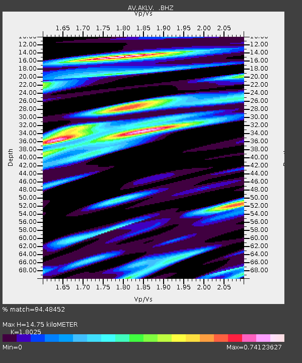
| Estimated Moho Depth: |
14.75 km |
| Estimated Crust Vp/Vs: |
1.80 |
| Assumed Crust Vp: |
5.989 km/s |
| Estimated Crust Vs: |
3.323 km/s |
| Estimated Crust Poisson's Ratio: |
0.28 |
|
| Radial Match: |
94.48452 % |
| Radial Bump: |
400 |
| Transverse Match: |
92.41553 % |
| Transverse Bump: |
400 |
| SOD ConfigId: |
2648 |
| Insert Time: |
2010-03-09 01:19:36.463 +0000 |
| GWidth: |
2.5 |
| Max Bumps: |
400 |
| Tol: |
0.001 |
|
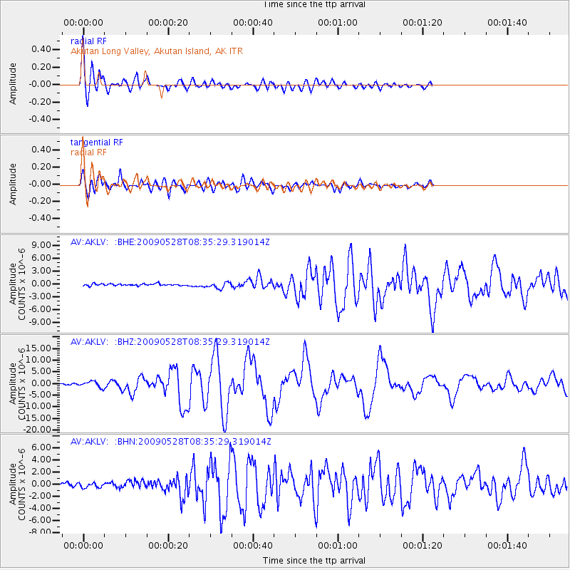
Signal To Noise
| Channel | StoN | STA | LTA |
| AV:AKLV: :BHZ:20090528T08:35:29.319014Z | 6.0355544 | 1.3239983E-6 | 2.1936647E-7 |
| AV:AKLV: :BHN:20090528T08:35:29.319014Z | 1.0453588 | 3.571368E-7 | 3.4164043E-7 |
| AV:AKLV: :BHE:20090528T08:35:29.319014Z | 3.4703321 | 7.0195625E-7 | 2.022735E-7 |
| Arrivals |
| Ps | 2.0 SECOND |
| PpPs | 6.7 SECOND |
| PsPs/PpSs | 8.7 SECOND |


