You are here: Home > Network List > US - United States National Seismic Network Stations List
> Station AMTX Amarillo, Texas, USA > Earthquake Result Viewer
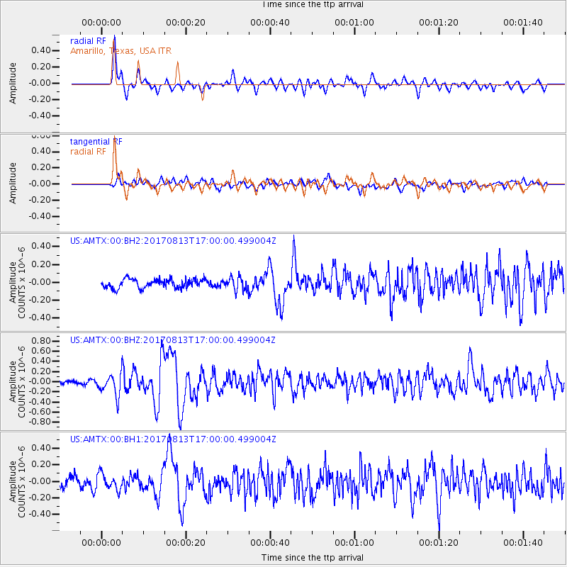
AMTX Amarillo, Texas, USA - Earthquake Result Viewer
*The percent match for this event was below the threshold and hence no stack was calculated.
| Earthquake location: |
Central Peru |
| Earthquake latitude/longitude: |
-10.7/-74.6 |
| Earthquake time(UTC): |
2017/08/13 (225) 16:51:22 GMT |
| Earthquake Depth: |
21 km |
| Earthquake Magnitude: |
5.6 mb |
| Earthquake Catalog/Contributor: |
NEIC PDE/us |
|
| Network: |
US United States National Seismic Network |
| Station: |
AMTX Amarillo, Texas, USA |
| Lat/Lon: |
34.53 N/101.41 W |
| Elevation: |
1010 m |
|
| Distance: |
51.7 deg |
| Az: |
331.638 deg |
| Baz: |
145.563 deg |
| Ray Param: |
$rayparam |
*The percent match for this event was below the threshold and hence was not used in the summary stack. |
|
| Radial Match: |
82.220634 % |
| Radial Bump: |
400 |
| Transverse Match: |
68.829895 % |
| Transverse Bump: |
400 |
| SOD ConfigId: |
2140511 |
| Insert Time: |
2017-08-27 08:52:28.209 +0000 |
| GWidth: |
2.5 |
| Max Bumps: |
400 |
| Tol: |
0.001 |
|
Signal To Noise
| Channel | StoN | STA | LTA |
| US:AMTX:00:BHZ:20170813T17:00:00.499004Z | 2.865934 | 2.1628546E-7 | 7.546771E-8 |
| US:AMTX:00:BH1:20170813T17:00:00.499004Z | 1.9358163 | 9.8788135E-8 | 5.1031773E-8 |
| US:AMTX:00:BH2:20170813T17:00:00.499004Z | 0.8561914 | 4.2334047E-8 | 4.9444605E-8 |
| Arrivals |
| Ps | |
| PpPs | |
| PsPs/PpSs | |


