You are here: Home > Network List > AV - Alaska Volcano Observatory Stations List
> Station AKRB Akutan Reef Bight, Akutan Island, AK > Earthquake Result Viewer
AKRB Akutan Reef Bight, Akutan Island, AK - Earthquake Result Viewer
| Earthquake location: |
Mariana Islands |
| Earthquake latitude/longitude: |
18.9/145.4 |
| Earthquake time(UTC): |
2007/10/31 (304) 03:30:17 GMT |
| Earthquake Depth: |
223 km |
| Earthquake Magnitude: |
6.2 MB, 7.2 MW, 7.2 MW |
| Earthquake Catalog/Contributor: |
WHDF/NEIC |
|
| Network: |
AV Alaska Volcano Observatory |
| Station: |
AKRB Akutan Reef Bight, Akutan Island, AK |
| Lat/Lon: |
54.13 N/166.07 W |
| Elevation: |
334 m |
|
| Distance: |
51.0 deg |
| Az: |
34.581 deg |
| Baz: |
245.931 deg |
| Ray Param: |
0.066859335 |
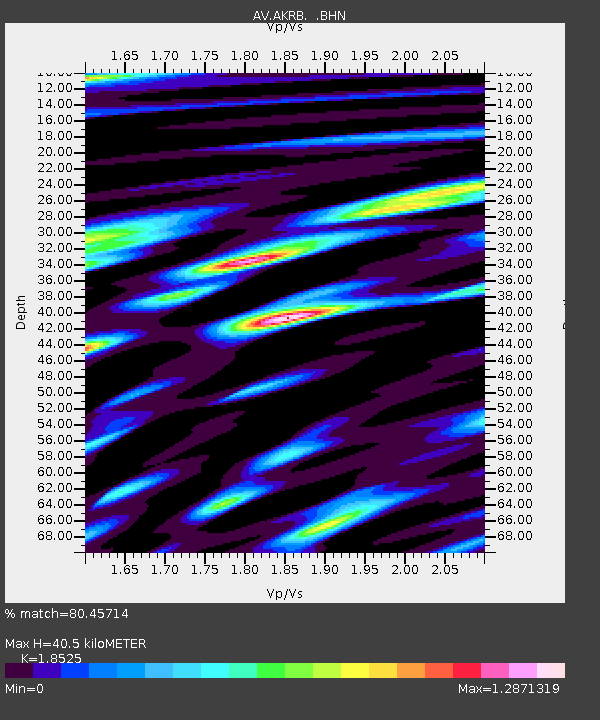
| Estimated Moho Depth: |
40.5 km |
| Estimated Crust Vp/Vs: |
1.85 |
| Assumed Crust Vp: |
5.989 km/s |
| Estimated Crust Vs: |
3.233 km/s |
| Estimated Crust Poisson's Ratio: |
0.29 |
|
| Radial Match: |
80.45714 % |
| Radial Bump: |
400 |
| Transverse Match: |
70.52045 % |
| Transverse Bump: |
400 |
| SOD ConfigId: |
2564 |
| Insert Time: |
2010-03-09 01:19:51.851 +0000 |
| GWidth: |
2.5 |
| Max Bumps: |
400 |
| Tol: |
0.001 |
|

Signal To Noise
| Channel | StoN | STA | LTA |
| AV:AKRB: :BHN:20071031T03:38:26.179012Z | 3.4632225 | 1.3509236E-5 | 3.9007705E-6 |
| AV:AKRB: :BHE:20071031T03:38:26.179012Z | 4.2817183 | 1.0076138E-5 | 2.3532932E-6 |
| AV:AKRB: :BHZ:20071031T03:38:26.179012Z | 7.776653 | 1.7099825E-5 | 2.198867E-6 |
| Arrivals |
| Ps | 6.0 SECOND |
| PpPs | 18 SECOND |
| PsPs/PpSs | 24 SECOND |


