You are here: Home > Network List > US - United States National Seismic Network Stations List
> Station LKWY Lake (Yellowstone--Lake), Wyoming, USA > Earthquake Result Viewer
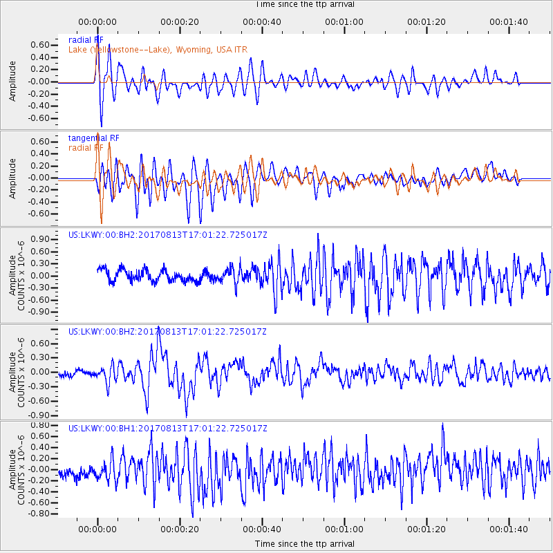
LKWY Lake (Yellowstone--Lake), Wyoming, USA - Earthquake Result Viewer
*The percent match for this event was below the threshold and hence no stack was calculated.
| Earthquake location: |
Central Peru |
| Earthquake latitude/longitude: |
-10.7/-74.6 |
| Earthquake time(UTC): |
2017/08/13 (225) 16:51:22 GMT |
| Earthquake Depth: |
21 km |
| Earthquake Magnitude: |
5.6 mb |
| Earthquake Catalog/Contributor: |
NEIC PDE/us |
|
| Network: |
US United States National Seismic Network |
| Station: |
LKWY Lake (Yellowstone--Lake), Wyoming, USA |
| Lat/Lon: |
44.57 N/110.40 W |
| Elevation: |
2424 m |
|
| Distance: |
63.9 deg |
| Az: |
332.217 deg |
| Baz: |
140.142 deg |
| Ray Param: |
$rayparam |
*The percent match for this event was below the threshold and hence was not used in the summary stack. |
|
| Radial Match: |
73.522255 % |
| Radial Bump: |
400 |
| Transverse Match: |
71.60254 % |
| Transverse Bump: |
400 |
| SOD ConfigId: |
2140511 |
| Insert Time: |
2017-08-27 08:53:09.074 +0000 |
| GWidth: |
2.5 |
| Max Bumps: |
400 |
| Tol: |
0.001 |
|
Signal To Noise
| Channel | StoN | STA | LTA |
| US:LKWY:00:BHZ:20170813T17:01:22.725017Z | 2.565654 | 1.6847261E-7 | 6.566459E-8 |
| US:LKWY:00:BH1:20170813T17:01:22.725017Z | 1.3000377 | 2.2869865E-7 | 1.7591694E-7 |
| US:LKWY:00:BH2:20170813T17:01:22.725017Z | 1.3387396 | 1.872049E-7 | 1.3983669E-7 |
| Arrivals |
| Ps | |
| PpPs | |
| PsPs/PpSs | |


