You are here: Home > Network List > TA - USArray Transportable Network (new EarthScope stations) Stations List
> Station E20K Nigu River, AK, USA > Earthquake Result Viewer
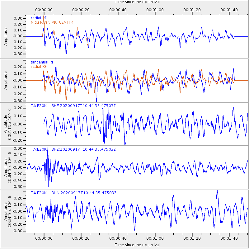
E20K Nigu River, AK, USA - Earthquake Result Viewer
*The percent match for this event was below the threshold and hence no stack was calculated.
| Earthquake location: |
Banda Sea |
| Earthquake latitude/longitude: |
-6.8/129.4 |
| Earthquake time(UTC): |
2020/09/17 (261) 10:32:25 GMT |
| Earthquake Depth: |
183 km |
| Earthquake Magnitude: |
5.5 Mww |
| Earthquake Catalog/Contributor: |
NEIC PDE/us |
|
| Network: |
TA USArray Transportable Network (new EarthScope stations) |
| Station: |
E20K Nigu River, AK, USA |
| Lat/Lon: |
68.26 N/156.19 W |
| Elevation: |
866 m |
|
| Distance: |
90.5 deg |
| Az: |
21.037 deg |
| Baz: |
253.097 deg |
| Ray Param: |
$rayparam |
*The percent match for this event was below the threshold and hence was not used in the summary stack. |
|
| Radial Match: |
54.19416 % |
| Radial Bump: |
400 |
| Transverse Match: |
57.920807 % |
| Transverse Bump: |
400 |
| SOD ConfigId: |
22732711 |
| Insert Time: |
2020-10-01 10:39:03.271 +0000 |
| GWidth: |
2.5 |
| Max Bumps: |
400 |
| Tol: |
0.001 |
|
Signal To Noise
| Channel | StoN | STA | LTA |
| TA:E20K: :BHZ:20200917T10:44:35.47503Z | 3.4670653 | 2.7419577E-7 | 7.9085844E-8 |
| TA:E20K: :BHN:20200917T10:44:35.47503Z | 0.9655648 | 9.0621924E-8 | 9.385381E-8 |
| TA:E20K: :BHE:20200917T10:44:35.47503Z | 1.3720121 | 1.137826E-7 | 8.293119E-8 |
| Arrivals |
| Ps | |
| PpPs | |
| PsPs/PpSs | |


