You are here: Home > Network List > TX - Texas Seismological Network Stations List
> Station 833A Chaparral WMA, Artesia Wells, TX, USA > Earthquake Result Viewer
833A Chaparral WMA, Artesia Wells, TX, USA - Earthquake Result Viewer
| Earthquake location: |
Fiji Islands Region |
| Earthquake latitude/longitude: |
-16.5/-177.3 |
| Earthquake time(UTC): |
2020/09/17 (261) 17:01:32 GMT |
| Earthquake Depth: |
10 km |
| Earthquake Magnitude: |
5.6 Mww |
| Earthquake Catalog/Contributor: |
NEIC PDE/us |
|
| Network: |
TX Texas Seismological Network |
| Station: |
833A Chaparral WMA, Artesia Wells, TX, USA |
| Lat/Lon: |
28.32 N/99.39 W |
| Elevation: |
171 m |
|
| Distance: |
87.5 deg |
| Az: |
59.633 deg |
| Baz: |
249.857 deg |
| Ray Param: |
0.04330806 |
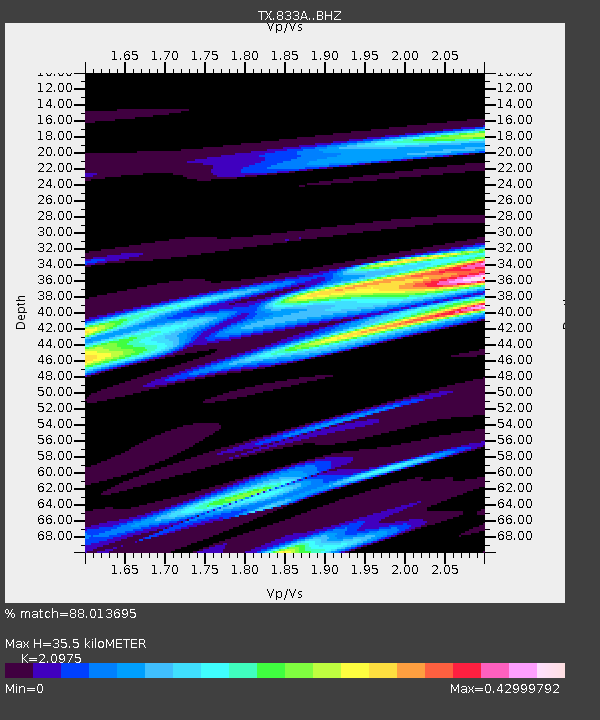
| Estimated Moho Depth: |
35.5 km |
| Estimated Crust Vp/Vs: |
2.10 |
| Assumed Crust Vp: |
6.347 km/s |
| Estimated Crust Vs: |
3.026 km/s |
| Estimated Crust Poisson's Ratio: |
0.35 |
|
| Radial Match: |
88.013695 % |
| Radial Bump: |
251 |
| Transverse Match: |
57.108562 % |
| Transverse Bump: |
398 |
| SOD ConfigId: |
22732711 |
| Insert Time: |
2020-10-01 17:15:49.058 +0000 |
| GWidth: |
2.5 |
| Max Bumps: |
400 |
| Tol: |
0.001 |
|

Signal To Noise
| Channel | StoN | STA | LTA |
| TX:833A: :BHZ:20200917T17:13:48.100022Z | 2.7683895 | 2.0967E-7 | 7.573718E-8 |
| TX:833A: :BHN:20200917T17:13:48.100022Z | 1.6458073 | 1.8146969E-7 | 1.1026181E-7 |
| TX:833A: :BHE:20200917T17:13:48.100022Z | 2.6740916 | 1.4218328E-7 | 5.3170687E-8 |
| Arrivals |
| Ps | 6.3 SECOND |
| PpPs | 17 SECOND |
| PsPs/PpSs | 23 SECOND |


