You are here: Home > Network List > UU - University of Utah Regional Network Stations List
> Station KNB Kanab, UT, USA > Earthquake Result Viewer
KNB Kanab, UT, USA - Earthquake Result Viewer
| Earthquake location: |
Central Peru |
| Earthquake latitude/longitude: |
-10.7/-74.6 |
| Earthquake time(UTC): |
2017/08/13 (225) 16:51:22 GMT |
| Earthquake Depth: |
21 km |
| Earthquake Magnitude: |
5.6 mb |
| Earthquake Catalog/Contributor: |
NEIC PDE/us |
|
| Network: |
UU University of Utah Regional Network |
| Station: |
KNB Kanab, UT, USA |
| Lat/Lon: |
37.02 N/112.82 W |
| Elevation: |
1715 m |
|
| Distance: |
59.5 deg |
| Az: |
324.902 deg |
| Baz: |
135.088 deg |
| Ray Param: |
0.062101107 |
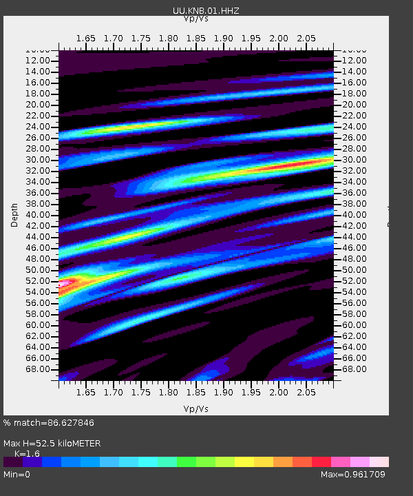
| Estimated Moho Depth: |
52.5 km |
| Estimated Crust Vp/Vs: |
1.60 |
| Assumed Crust Vp: |
6.194 km/s |
| Estimated Crust Vs: |
3.871 km/s |
| Estimated Crust Poisson's Ratio: |
0.18 |
|
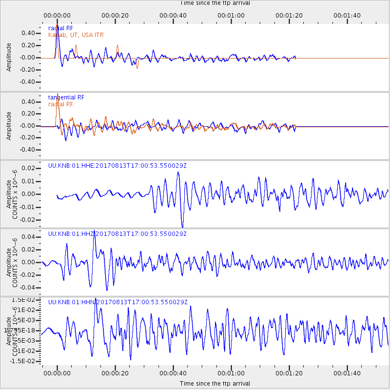
| Radial Match: |
86.627846 % |
| Radial Bump: |
395 |
| Transverse Match: |
75.97027 % |
| Transverse Bump: |
400 |
| SOD ConfigId: |
2140511 |
| Insert Time: |
2017-08-27 08:53:52.442 +0000 |
| GWidth: |
2.5 |
| Max Bumps: |
400 |
| Tol: |
0.001 |
|
Signal To Noise
| Channel | StoN | STA | LTA |
| UU:KNB:01:HHZ:20170813T17:00:53.550029Z | 5.93826 | 1.3469235E-8 | 2.2682123E-9 |
| UU:KNB:01:HHN:20170813T17:00:53.550029Z | 2.3312786 | 3.9647228E-9 | 1.7006646E-9 |
| UU:KNB:01:HHE:20170813T17:00:53.550029Z | 2.941468 | 5.5393268E-9 | 1.8831845E-9 |
| Arrivals |
| Ps | 5.3 SECOND |
| PpPs | 21 SECOND |
| PsPs/PpSs | 26 SECOND |


