You are here: Home > Network List > AV - Alaska Volcano Observatory Stations List
> Station OKFG Okmok Caldera, Umnak Island, Alaska > Earthquake Result Viewer
OKFG Okmok Caldera, Umnak Island, Alaska - Earthquake Result Viewer
| Earthquake location: |
North Of Honduras |
| Earthquake latitude/longitude: |
16.7/-86.2 |
| Earthquake time(UTC): |
2009/05/28 (148) 08:24:45 GMT |
| Earthquake Depth: |
10 km |
| Earthquake Magnitude: |
6.7 MB, 7.2 MS, 7.3 MW, 7.3 MW |
| Earthquake Catalog/Contributor: |
WHDF/NEIC |
|
| Network: |
AV Alaska Volcano Observatory |
| Station: |
OKFG Okmok Caldera, Umnak Island, Alaska |
| Lat/Lon: |
53.41 N/167.91 W |
| Elevation: |
201 m |
|
| Distance: |
71.8 deg |
| Az: |
321.43 deg |
| Baz: |
86.376 deg |
| Ray Param: |
0.05407586 |
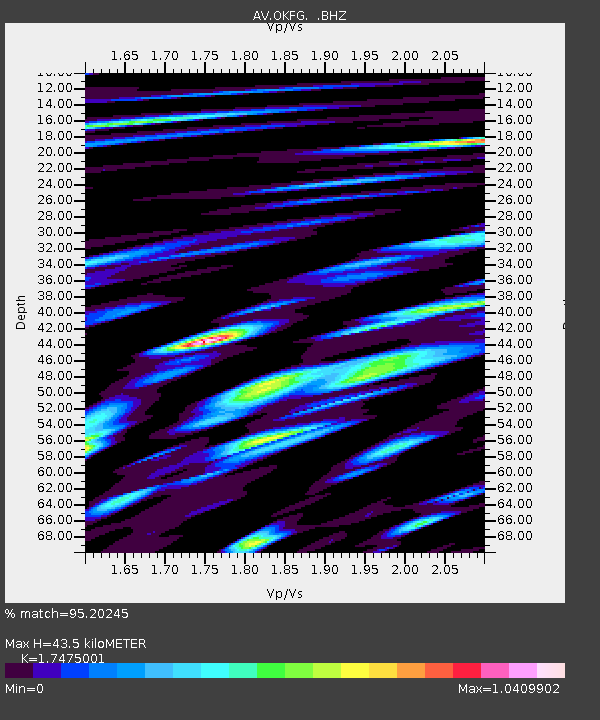
| Estimated Moho Depth: |
43.5 km |
| Estimated Crust Vp/Vs: |
1.75 |
| Assumed Crust Vp: |
3.943 km/s |
| Estimated Crust Vs: |
2.257 km/s |
| Estimated Crust Poisson's Ratio: |
0.26 |
|
| Radial Match: |
95.20245 % |
| Radial Bump: |
400 |
| Transverse Match: |
88.18535 % |
| Transverse Bump: |
400 |
| SOD ConfigId: |
2648 |
| Insert Time: |
2010-03-09 01:21:34.228 +0000 |
| GWidth: |
2.5 |
| Max Bumps: |
400 |
| Tol: |
0.001 |
|

Signal To Noise
| Channel | StoN | STA | LTA |
| AV:OKFG: :BHZ:20090528T08:35:36.220015Z | 6.850057 | 1.6130386E-6 | 2.3547814E-7 |
| AV:OKFG: :BHN:20090528T08:35:36.220015Z | 1.1063262 | 2.5456296E-7 | 2.3009754E-7 |
| AV:OKFG: :BHE:20090528T08:35:36.220015Z | 3.2177222 | 7.0227367E-7 | 2.182518E-7 |
| Arrivals |
| Ps | 8.4 SECOND |
| PpPs | 30 SECOND |
| PsPs/PpSs | 38 SECOND |


