You are here: Home > Network List > AV - Alaska Volcano Observatory Stations List
> Station OKSO Okmok Caldera, Umnak Island, Alaska > Earthquake Result Viewer
OKSO Okmok Caldera, Umnak Island, Alaska - Earthquake Result Viewer
| Earthquake location: |
Tonga Islands Region |
| Earthquake latitude/longitude: |
-23.0/-174.7 |
| Earthquake time(UTC): |
2009/03/19 (078) 18:17:40 GMT |
| Earthquake Depth: |
34 km |
| Earthquake Magnitude: |
7.0 MB, 7.6 MS, 7.6 MW, 7.6 MW |
| Earthquake Catalog/Contributor: |
WHDF/NEIC |
|
| Network: |
AV Alaska Volcano Observatory |
| Station: |
OKSO Okmok Caldera, Umnak Island, Alaska |
| Lat/Lon: |
53.36 N/168.16 W |
| Elevation: |
460 m |
|
| Distance: |
76.3 deg |
| Az: |
4.005 deg |
| Baz: |
186.161 deg |
| Ray Param: |
0.051044825 |
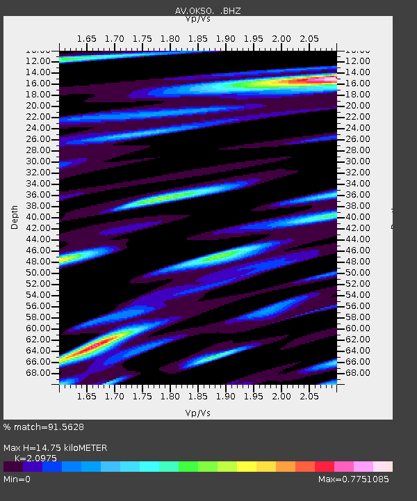
| Estimated Moho Depth: |
14.75 km |
| Estimated Crust Vp/Vs: |
2.10 |
| Assumed Crust Vp: |
5.88 km/s |
| Estimated Crust Vs: |
2.804 km/s |
| Estimated Crust Poisson's Ratio: |
0.35 |
|
| Radial Match: |
91.5628 % |
| Radial Bump: |
400 |
| Transverse Match: |
81.11928 % |
| Transverse Bump: |
400 |
| SOD ConfigId: |
2658 |
| Insert Time: |
2010-03-09 01:21:51.072 +0000 |
| GWidth: |
2.5 |
| Max Bumps: |
400 |
| Tol: |
0.001 |
|

Signal To Noise
| Channel | StoN | STA | LTA |
| AV:OKSO: :BHZ:20090319T18:28:55.240017Z | 19.355297 | 1.0202457E-5 | 5.271145E-7 |
| AV:OKSO: :BHN:20090319T18:28:55.240017Z | 2.2693942 | 4.859256E-6 | 2.141213E-6 |
| AV:OKSO: :BHE:20090319T18:28:55.240017Z | 1.262764 | 1.5685804E-6 | 1.2421802E-6 |
| Arrivals |
| Ps | 2.8 SECOND |
| PpPs | 7.6 SECOND |
| PsPs/PpSs | 10 SECOND |


