You are here: Home > Network List > GM - US Geological Survey Networks Stations List
> Station IWM01 Jericho 2M Well Monitoring Station > Earthquake Result Viewer
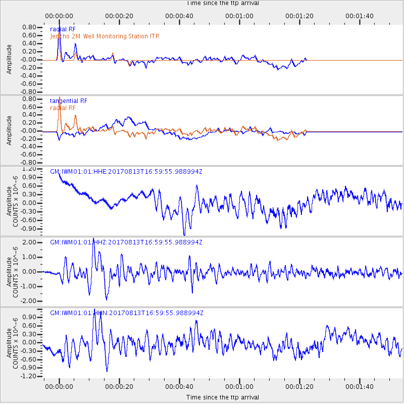
IWM01 Jericho 2M Well Monitoring Station - Earthquake Result Viewer
*The percent match for this event was below the threshold and hence no stack was calculated.
| Earthquake location: |
Central Peru |
| Earthquake latitude/longitude: |
-10.7/-74.6 |
| Earthquake time(UTC): |
2017/08/13 (225) 16:51:22 GMT |
| Earthquake Depth: |
21 km |
| Earthquake Magnitude: |
5.6 mb |
| Earthquake Catalog/Contributor: |
NEIC PDE/us |
|
| Network: |
GM US Geological Survey Networks |
| Station: |
IWM01 Jericho 2M Well Monitoring Station |
| Lat/Lon: |
36.73 N/96.53 W |
| Elevation: |
328 m |
|
| Distance: |
51.5 deg |
| Az: |
337.422 deg |
| Baz: |
151.987 deg |
| Ray Param: |
$rayparam |
*The percent match for this event was below the threshold and hence was not used in the summary stack. |
|
| Radial Match: |
46.42005 % |
| Radial Bump: |
400 |
| Transverse Match: |
22.826347 % |
| Transverse Bump: |
400 |
| SOD ConfigId: |
2140511 |
| Insert Time: |
2017-08-27 08:55:41.277 +0000 |
| GWidth: |
2.5 |
| Max Bumps: |
400 |
| Tol: |
0.001 |
|
Signal To Noise
| Channel | StoN | STA | LTA |
| GM:IWM01:01:HHZ:20170813T16:59:55.988994Z | 7.5713987 | 5.028454E-7 | 6.6413804E-8 |
| GM:IWM01:01:HHN:20170813T16:59:55.988994Z | 3.046999 | 5.6426694E-7 | 1.8518776E-7 |
| GM:IWM01:01:HHE:20170813T16:59:55.988994Z | 1.1153395 | 3.1480732E-7 | 2.8225244E-7 |
| Arrivals |
| Ps | |
| PpPs | |
| PsPs/PpSs | |


