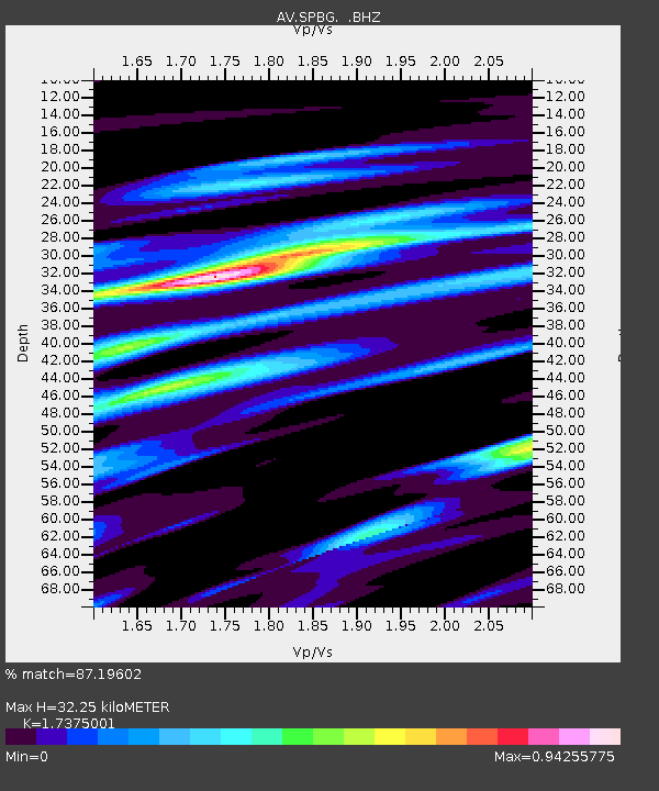
SPBG Mount Spurr - Barrier Glacier - Earthquake Result Viewer

Earthquake location: Vanuatu Islands
Earthquake latitude/longitude: -14.8/168.0
Earthquake time(UTC): 2008/11/07 (312) 07:19:35 GMT
Earthquake Depth: 13 km
Earthquake Magnitude: 6.0 MB, 6.3 MS, 6.4 MW, 6.4 MW
Earthquake Catalog/Contributor: WHDF/NEIC
Network: AV Alaska Volcano Observatory
Station: SPBG Mount Spurr - Barrier Glacier
Lat/Lon: 61.26 N/152.37 W
Elevation: 1087 m
Distance: 82.1 deg
Az: 18.121 deg
Baz: 218.488 deg
Ray Param: 0.047119208
Estimated Moho Depth: 32.25 km
Estimated Crust Vp/Vs: 1.74
Assumed Crust Vp: 6.566 km/s
Estimated Crust Vs: 3.779 km/s
Estimated Crust Poisson's Ratio: 0.25
Radial Match: 87.19602 %
Radial Bump: 400
Transverse Match: 85.06118 %
Transverse Bump: 400
SOD ConfigId: 2658
Insert Time: 2010-03-09 01:22:09.585 +0000
GWidth: 2.5
Max Bumps: 400
Tol: 0.001

Signal To Noise

ChannelStoNSTALTA
AV:SPBG: :BHZ:20081107T07:31:24.340005Z9.9239651.6172667E-61.6296576E-7
AV:SPBG: :BHN:20081107T07:31:24.340005Z3.0971025.632818E-71.8187383E-7
AV:SPBG: :BHE:20081107T07:31:24.340005Z1.6892993.019138E-71.7872134E-7
Arrivals
Ps3.7 SECOND
PpPs13 SECOND
PsPs/PpSs17 SECOND