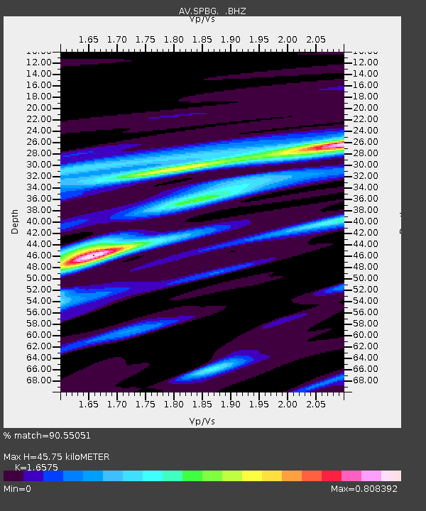
SPBG Mount Spurr - Barrier Glacier - Earthquake Result Viewer

Earthquake location: Loyalty Islands
Earthquake latitude/longitude: -20.1/168.9
Earthquake time(UTC): 2008/04/09 (100) 12:46:12 GMT
Earthquake Depth: 33 km
Earthquake Magnitude: 6.3 MB, 7.3 MS, 7.3 MW, 7.3 MW
Earthquake Catalog/Contributor: WHDF/NEIC
Network: AV Alaska Volcano Observatory
Station: SPBG Mount Spurr - Barrier Glacier
Lat/Lon: 61.26 N/152.37 W
Elevation: 1087 m
Distance: 86.8 deg
Az: 17.633 deg
Baz: 216.096 deg
Ray Param: 0.043740712
Estimated Moho Depth: 45.75 km
Estimated Crust Vp/Vs: 1.66
Assumed Crust Vp: 6.566 km/s
Estimated Crust Vs: 3.961 km/s
Estimated Crust Poisson's Ratio: 0.21
Radial Match: 90.55051 %
Radial Bump: 400
Transverse Match: 85.29714 %
Transverse Bump: 400
SOD ConfigId: 2504
Insert Time: 2010-03-09 01:22:12.817 +0000
GWidth: 2.5
Max Bumps: 400
Tol: 0.001

Signal To Noise

ChannelStoNSTALTA
AV:SPBG: :BHZ:20080409T12:58:22.48001Z24.4705945.658481E-62.3123596E-7
AV:SPBG: :BHN:20080409T12:58:22.48001Z11.5638061.8567885E-61.6056897E-7
AV:SPBG: :BHE:20080409T12:58:22.48001Z0.93124191.6579519E-71.7803663E-7
Arrivals
Ps4.7 SECOND
PpPs18 SECOND
PsPs/PpSs23 SECOND