You are here: Home > Network List > G - GEOSCOPE Stations List
> Station FDFM Morne la Rosette, Martinique, France > Earthquake Result Viewer
FDFM Morne la Rosette, Martinique, France - Earthquake Result Viewer
| Earthquake location: |
Central Mid-Atlantic Ridge |
| Earthquake latitude/longitude: |
1.0/-26.8 |
| Earthquake time(UTC): |
2020/09/18 (262) 21:43:59 GMT |
| Earthquake Depth: |
10 km |
| Earthquake Magnitude: |
6.9 Mww |
| Earthquake Catalog/Contributor: |
NEIC PDE/us |
|
| Network: |
G GEOSCOPE |
| Station: |
FDFM Morne la Rosette, Martinique, France |
| Lat/Lon: |
14.73 N/61.16 W |
| Elevation: |
320 m |
|
| Distance: |
36.6 deg |
| Az: |
293.692 deg |
| Baz: |
108.859 deg |
| Ray Param: |
0.07663929 |
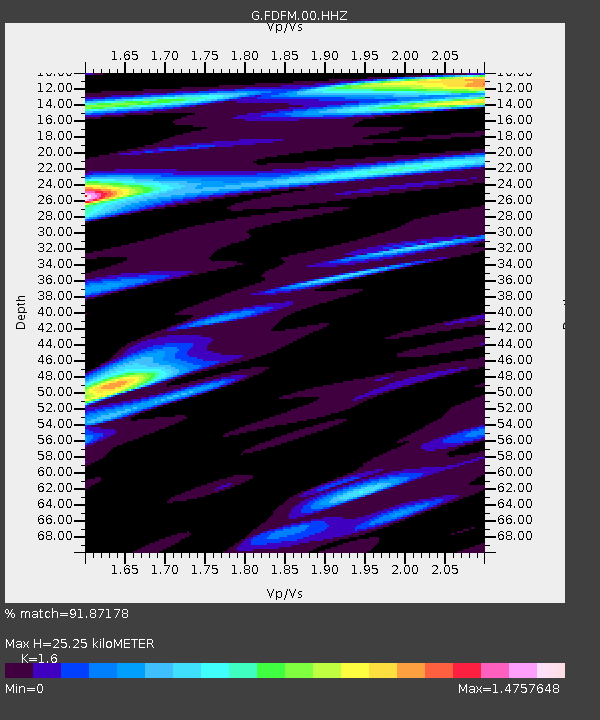
| Estimated Moho Depth: |
25.25 km |
| Estimated Crust Vp/Vs: |
1.60 |
| Assumed Crust Vp: |
5.88 km/s |
| Estimated Crust Vs: |
3.675 km/s |
| Estimated Crust Poisson's Ratio: |
0.18 |
|
| Radial Match: |
91.87178 % |
| Radial Bump: |
313 |
| Transverse Match: |
80.50748 % |
| Transverse Bump: |
400 |
| SOD ConfigId: |
22732711 |
| Insert Time: |
2020-10-02 21:53:59.280 +0000 |
| GWidth: |
2.5 |
| Max Bumps: |
400 |
| Tol: |
0.001 |
|

Signal To Noise
| Channel | StoN | STA | LTA |
| G:FDFM:00:HHZ:20200918T21:50:34.619Z | 7.53226 | 3.0415977E-6 | 4.0380942E-7 |
| G:FDFM:00:HHN:20200918T21:50:34.619Z | 1.3247721 | 9.754172E-7 | 7.362905E-7 |
| G:FDFM:00:HHE:20200918T21:50:34.619Z | 4.635289 | 2.5685097E-6 | 5.541207E-7 |
| Arrivals |
| Ps | 2.8 SECOND |
| PpPs | 10 SECOND |
| PsPs/PpSs | 13 SECOND |


