You are here: Home > Network List > GM - US Geological Survey Networks Stations List
> Station NMP25 New Mexico Permian - Site# W2S5 > Earthquake Result Viewer
NMP25 New Mexico Permian - Site# W2S5 - Earthquake Result Viewer
| Earthquake location: |
Central Mid-Atlantic Ridge |
| Earthquake latitude/longitude: |
1.0/-26.8 |
| Earthquake time(UTC): |
2020/09/18 (262) 21:43:59 GMT |
| Earthquake Depth: |
10 km |
| Earthquake Magnitude: |
6.9 Mww |
| Earthquake Catalog/Contributor: |
NEIC PDE/us |
|
| Network: |
GM US Geological Survey Networks |
| Station: |
NMP25 New Mexico Permian - Site# W2S5 |
| Lat/Lon: |
32.34 N/103.86 W |
| Elevation: |
983 m |
|
| Distance: |
78.5 deg |
| Az: |
302.676 deg |
| Baz: |
96.174 deg |
| Ray Param: |
0.04958164 |
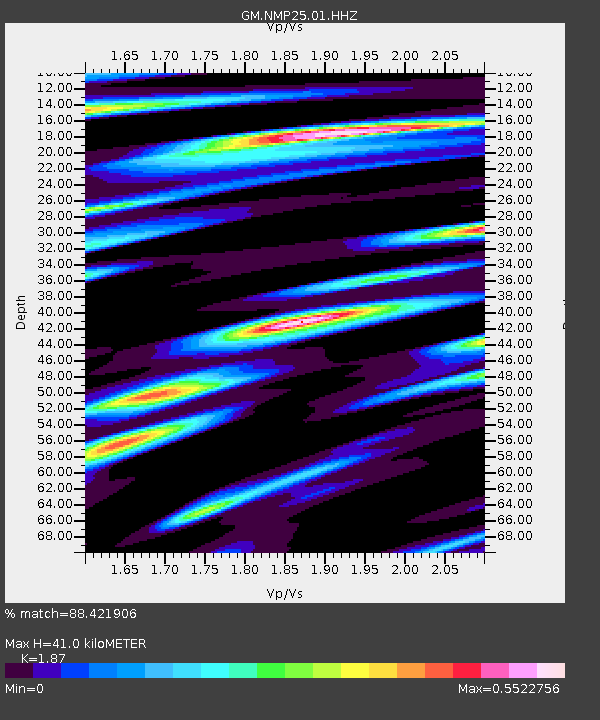
| Estimated Moho Depth: |
41.0 km |
| Estimated Crust Vp/Vs: |
1.87 |
| Assumed Crust Vp: |
6.129 km/s |
| Estimated Crust Vs: |
3.277 km/s |
| Estimated Crust Poisson's Ratio: |
0.30 |
|
| Radial Match: |
88.421906 % |
| Radial Bump: |
400 |
| Transverse Match: |
77.638405 % |
| Transverse Bump: |
400 |
| SOD ConfigId: |
22732711 |
| Insert Time: |
2020-10-02 21:55:17.584 +0000 |
| GWidth: |
2.5 |
| Max Bumps: |
400 |
| Tol: |
0.001 |
|

Signal To Noise
| Channel | StoN | STA | LTA |
| GM:NMP25:01:HHZ:20200918T21:55:29.489972Z | 1.7688609 | 5.8312173E-7 | 3.2965946E-7 |
| GM:NMP25:01:HHN:20200918T21:55:29.489972Z | 0.66369075 | 1.3814545E-7 | 2.0814733E-7 |
| GM:NMP25:01:HHE:20200918T21:55:29.489972Z | 1.4134283 | 2.3169441E-7 | 1.6392372E-7 |
| Arrivals |
| Ps | 6.0 SECOND |
| PpPs | 19 SECOND |
| PsPs/PpSs | 25 SECOND |


