You are here: Home > Network List > GT - Global Telemetered Seismograph Network (USAF/USGS) Stations List
> Station LPAZ La Paz , Bolivia > Earthquake Result Viewer
LPAZ La Paz , Bolivia - Earthquake Result Viewer
| Earthquake location: |
Central Mid-Atlantic Ridge |
| Earthquake latitude/longitude: |
1.0/-26.8 |
| Earthquake time(UTC): |
2020/09/18 (262) 21:43:59 GMT |
| Earthquake Depth: |
10 km |
| Earthquake Magnitude: |
6.9 Mww |
| Earthquake Catalog/Contributor: |
NEIC PDE/us |
|
| Network: |
GT Global Telemetered Seismograph Network (USAF/USGS) |
| Station: |
LPAZ La Paz , Bolivia |
| Lat/Lon: |
16.17 S/68.08 W |
| Elevation: |
4817 m |
|
| Distance: |
44.1 deg |
| Az: |
245.493 deg |
| Baz: |
71.224 deg |
| Ray Param: |
0.07212293 |
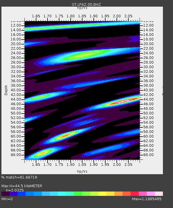
| Estimated Moho Depth: |
44.5 km |
| Estimated Crust Vp/Vs: |
2.03 |
| Assumed Crust Vp: |
6.454 km/s |
| Estimated Crust Vs: |
3.175 km/s |
| Estimated Crust Poisson's Ratio: |
0.34 |
|
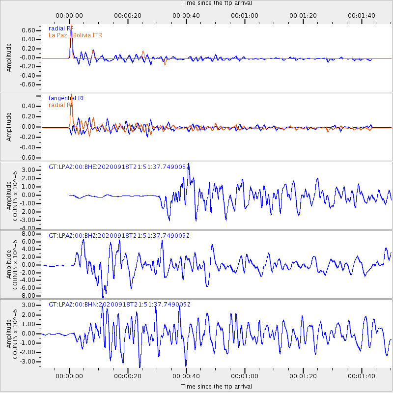
| Radial Match: |
91.66719 % |
| Radial Bump: |
400 |
| Transverse Match: |
88.52904 % |
| Transverse Bump: |
400 |
| SOD ConfigId: |
22732711 |
| Insert Time: |
2020-10-02 21:55:27.845 +0000 |
| GWidth: |
2.5 |
| Max Bumps: |
400 |
| Tol: |
0.001 |
|
Signal To Noise
| Channel | StoN | STA | LTA |
| GT:LPAZ:00:BHZ:20200918T21:51:37.749005Z | 16.307495 | 2.7194892E-6 | 1.6676316E-7 |
| GT:LPAZ:00:BHN:20200918T21:51:37.749005Z | 5.465439 | 6.061232E-7 | 1.109011E-7 |
| GT:LPAZ:00:BHE:20200918T21:51:37.749005Z | 12.004834 | 1.1053734E-6 | 9.207736E-8 |
| Arrivals |
| Ps | 7.5 SECOND |
| PpPs | 20 SECOND |
| PsPs/PpSs | 27 SECOND |


