You are here: Home > Network List > GS - US Geological Survey Networks Stations List
> Station VEA2 VEA1 > Earthquake Result Viewer
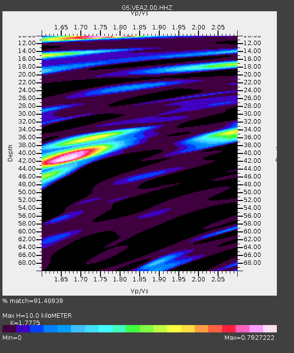
VEA2 VEA1 - Earthquake Result Viewer
| Earthquake location: |
Central Mid-Atlantic Ridge |
| Earthquake latitude/longitude: |
1.0/-26.8 |
| Earthquake time(UTC): |
2020/09/18 (262) 21:43:59 GMT |
| Earthquake Depth: |
10 km |
| Earthquake Magnitude: |
6.9 Mww |
| Earthquake Catalog/Contributor: |
NEIC PDE/us |
|
| Network: |
GS US Geological Survey Networks |
| Station: |
VEA2 VEA1 |
| Lat/Lon: |
34.94 N/106.46 W |
| Elevation: |
1844 m |
|
| Distance: |
80.9 deg |
| Az: |
305.087 deg |
| Baz: |
95.17 deg |
| Ray Param: |
0.047933564 |
| Estimated Moho Depth: |
10.0 km |
| Estimated Crust Vp/Vs: |
1.78 |
| Assumed Crust Vp: |
6.502 km/s |
| Estimated Crust Vs: |
3.658 km/s |
| Estimated Crust Poisson's Ratio: |
0.27 |
|
| Radial Match: |
91.48939 % |
| Radial Bump: |
400 |
| Transverse Match: |
81.2411 % |
| Transverse Bump: |
400 |
| SOD ConfigId: |
22732711 |
| Insert Time: |
2020-10-02 21:56:04.808 +0000 |
| GWidth: |
2.5 |
| Max Bumps: |
400 |
| Tol: |
0.001 |
|

Signal To Noise
| Channel | StoN | STA | LTA |
| GS:VEA2:00:HHZ:20200918T21:55:42.54997Z | 2.7618008 | 2.9263876E-7 | 1.059594E-7 |
| GS:VEA2:00:HH1:20200918T21:55:42.54997Z | 1.1762639 | 9.5290716E-8 | 8.101134E-8 |
| GS:VEA2:00:HH2:20200918T21:55:42.54997Z | 1.8797994 | 1.9239305E-7 | 1.0234765E-7 |
| Arrivals |
| Ps | 1.2 SECOND |
| PpPs | 4.2 SECOND |
| PsPs/PpSs | 5.4 SECOND |


