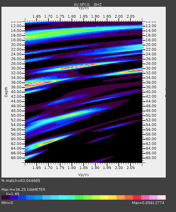
SPCG Mount Spurr - Capps Glacier - Earthquake Result Viewer

Earthquake location: Guerrero, Mexico
Earthquake latitude/longitude: 17.0/-99.4
Earthquake time(UTC): 2009/04/27 (117) 16:46:28 GMT
Earthquake Depth: 35 km
Earthquake Magnitude: 5.7 MB, 5.4 MS, 5.8 MW, 5.8 MW
Earthquake Catalog/Contributor: WHDF/NEIC
Network: AV Alaska Volcano Observatory
Station: SPCG Mount Spurr - Capps Glacier
Lat/Lon: 61.29 N/152.02 W
Elevation: 1329 m
Distance: 57.6 deg
Az: 332.995 deg
Baz: 115.88 deg
Ray Param: 0.06331811
Estimated Moho Depth: 36.25 km
Estimated Crust Vp/Vs: 1.65
Assumed Crust Vp: 6.566 km/s
Estimated Crust Vs: 3.98 km/s
Estimated Crust Poisson's Ratio: 0.21
Radial Match: 83.044685 %
Radial Bump: 400
Transverse Match: 59.752228 %
Transverse Bump: 337
SOD ConfigId: 2760
Insert Time: 2010-03-09 01:22:24.887 +0000
GWidth: 2.5
Max Bumps: 400
Tol: 0.001

Signal To Noise

ChannelStoNSTALTA
AV:SPCG: :BHZ:20090427T16:55:44.359001Z2.64856245.2198175E-71.9708118E-7
AV:SPCG: :BHN:20090427T16:55:44.359001Z2.35459284.59681E-71.9522739E-7
AV:SPCG: :BHE:20090427T16:55:44.359001Z3.53811886.131528E-71.7329909E-7
Arrivals
Ps3.8 SECOND
PpPs14 SECOND
PsPs/PpSs18 SECOND