You are here: Home > Network List > N4 - Central and EAstern US Network Stations List
> Station 451A Vernon, FL, USA > Earthquake Result Viewer
451A Vernon, FL, USA - Earthquake Result Viewer
| Earthquake location: |
Central Mid-Atlantic Ridge |
| Earthquake latitude/longitude: |
1.0/-26.8 |
| Earthquake time(UTC): |
2020/09/18 (262) 21:43:59 GMT |
| Earthquake Depth: |
10 km |
| Earthquake Magnitude: |
6.9 Mww |
| Earthquake Catalog/Contributor: |
NEIC PDE/us |
|
| Network: |
N4 Central and EAstern US Network |
| Station: |
451A Vernon, FL, USA |
| Lat/Lon: |
30.62 N/85.75 W |
| Elevation: |
20 m |
|
| Distance: |
63.0 deg |
| Az: |
304.069 deg |
| Baz: |
106.107 deg |
| Ray Param: |
0.05983761 |
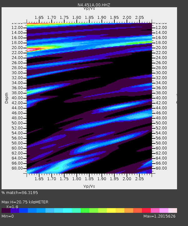
| Estimated Moho Depth: |
20.75 km |
| Estimated Crust Vp/Vs: |
1.60 |
| Assumed Crust Vp: |
6.347 km/s |
| Estimated Crust Vs: |
3.967 km/s |
| Estimated Crust Poisson's Ratio: |
0.18 |
|
| Radial Match: |
86.3195 % |
| Radial Bump: |
337 |
| Transverse Match: |
58.45463 % |
| Transverse Bump: |
393 |
| SOD ConfigId: |
22732711 |
| Insert Time: |
2020-10-02 21:59:04.461 +0000 |
| GWidth: |
2.5 |
| Max Bumps: |
400 |
| Tol: |
0.001 |
|

Signal To Noise
| Channel | StoN | STA | LTA |
| N4:451A:00:HHZ:20200918T21:53:55.470014Z | 2.4478078 | 1.4634945E-6 | 5.9787965E-7 |
| N4:451A:00:HH1:20200918T21:53:55.470014Z | 0.96723413 | 1.048055E-6 | 1.0835588E-6 |
| N4:451A:00:HH2:20200918T21:53:55.470014Z | 0.5307271 | 4.0793591E-7 | 7.6863597E-7 |
| Arrivals |
| Ps | 2.1 SECOND |
| PpPs | 8.1 SECOND |
| PsPs/PpSs | 10 SECOND |


