You are here: Home > Network List > N4 - Central and EAstern US Network Stations List
> Station M52A Chesterland, OH, USA > Earthquake Result Viewer
M52A Chesterland, OH, USA - Earthquake Result Viewer
| Earthquake location: |
Central Mid-Atlantic Ridge |
| Earthquake latitude/longitude: |
1.0/-26.8 |
| Earthquake time(UTC): |
2020/09/18 (262) 21:43:59 GMT |
| Earthquake Depth: |
10 km |
| Earthquake Magnitude: |
6.9 Mww |
| Earthquake Catalog/Contributor: |
NEIC PDE/us |
|
| Network: |
N4 Central and EAstern US Network |
| Station: |
M52A Chesterland, OH, USA |
| Lat/Lon: |
41.54 N/81.36 W |
| Elevation: |
382 m |
|
| Distance: |
63.5 deg |
| Az: |
316.901 deg |
| Baz: |
114.488 deg |
| Ray Param: |
0.059558876 |
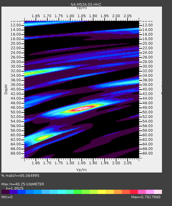
| Estimated Moho Depth: |
48.25 km |
| Estimated Crust Vp/Vs: |
1.85 |
| Assumed Crust Vp: |
6.483 km/s |
| Estimated Crust Vs: |
3.499 km/s |
| Estimated Crust Poisson's Ratio: |
0.29 |
|
| Radial Match: |
88.064995 % |
| Radial Bump: |
361 |
| Transverse Match: |
60.864803 % |
| Transverse Bump: |
400 |
| SOD ConfigId: |
22732711 |
| Insert Time: |
2020-10-02 22:00:05.364 +0000 |
| GWidth: |
2.5 |
| Max Bumps: |
400 |
| Tol: |
0.001 |
|

Signal To Noise
| Channel | StoN | STA | LTA |
| N4:M52A:00:HHZ:20200918T21:53:58.389997Z | 3.3173864 | 1.1021787E-6 | 3.322431E-7 |
| N4:M52A:00:HH1:20200918T21:53:58.389997Z | 1.1313069 | 3.7734827E-7 | 3.3355076E-7 |
| N4:M52A:00:HH2:20200918T21:53:58.389997Z | 1.7811204 | 5.678602E-7 | 3.188219E-7 |
| Arrivals |
| Ps | 6.6 SECOND |
| PpPs | 20 SECOND |
| PsPs/PpSs | 27 SECOND |


