You are here: Home > Network List > N4 - Central and EAstern US Network Stations List
> Station N51A Ashland, OH, USA > Earthquake Result Viewer
N51A Ashland, OH, USA - Earthquake Result Viewer
| Earthquake location: |
Central Mid-Atlantic Ridge |
| Earthquake latitude/longitude: |
1.0/-26.8 |
| Earthquake time(UTC): |
2020/09/18 (262) 21:43:59 GMT |
| Earthquake Depth: |
10 km |
| Earthquake Magnitude: |
6.9 Mww |
| Earthquake Catalog/Contributor: |
NEIC PDE/us |
|
| Network: |
N4 Central and EAstern US Network |
| Station: |
N51A Ashland, OH, USA |
| Lat/Lon: |
40.92 N/82.37 W |
| Elevation: |
343 m |
|
| Distance: |
63.9 deg |
| Az: |
315.92 deg |
| Baz: |
113.385 deg |
| Ray Param: |
0.059263915 |
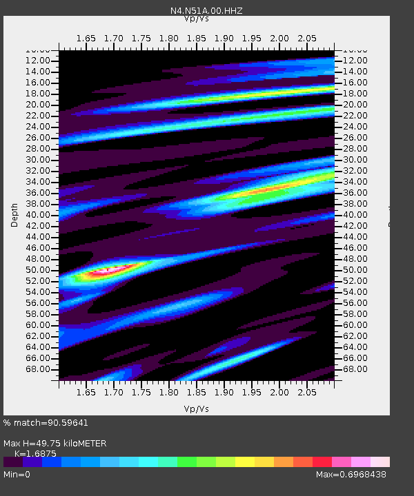
| Estimated Moho Depth: |
49.75 km |
| Estimated Crust Vp/Vs: |
1.69 |
| Assumed Crust Vp: |
6.498 km/s |
| Estimated Crust Vs: |
3.85 km/s |
| Estimated Crust Poisson's Ratio: |
0.23 |
|
| Radial Match: |
90.59641 % |
| Radial Bump: |
400 |
| Transverse Match: |
68.77403 % |
| Transverse Bump: |
400 |
| SOD ConfigId: |
22732711 |
| Insert Time: |
2020-10-02 22:00:17.110 +0000 |
| GWidth: |
2.5 |
| Max Bumps: |
400 |
| Tol: |
0.001 |
|

Signal To Noise
| Channel | StoN | STA | LTA |
| N4:N51A:00:HHZ:20200918T21:54:01.348981Z | 3.6644754 | 1.0081975E-6 | 2.7512738E-7 |
| N4:N51A:00:HH1:20200918T21:54:01.348981Z | 1.5126073 | 3.069244E-7 | 2.0291081E-7 |
| N4:N51A:00:HH2:20200918T21:54:01.348981Z | 2.0765028 | 4.6433166E-7 | 2.2361235E-7 |
| Arrivals |
| Ps | 5.5 SECOND |
| PpPs | 20 SECOND |
| PsPs/PpSs | 25 SECOND |


