You are here: Home > Network List > N4 - Central and EAstern US Network Stations List
> Station SPMN Marine on St. Croix, MN, USA > Earthquake Result Viewer
SPMN Marine on St. Croix, MN, USA - Earthquake Result Viewer
| Earthquake location: |
Central Mid-Atlantic Ridge |
| Earthquake latitude/longitude: |
1.0/-26.8 |
| Earthquake time(UTC): |
2020/09/18 (262) 21:43:59 GMT |
| Earthquake Depth: |
10 km |
| Earthquake Magnitude: |
6.9 Mww |
| Earthquake Catalog/Contributor: |
NEIC PDE/us |
|
| Network: |
N4 Central and EAstern US Network |
| Station: |
SPMN Marine on St. Croix, MN, USA |
| Lat/Lon: |
45.22 N/92.80 W |
| Elevation: |
311 m |
|
| Distance: |
72.6 deg |
| Az: |
317.428 deg |
| Baz: |
106.833 deg |
| Ray Param: |
0.05358373 |
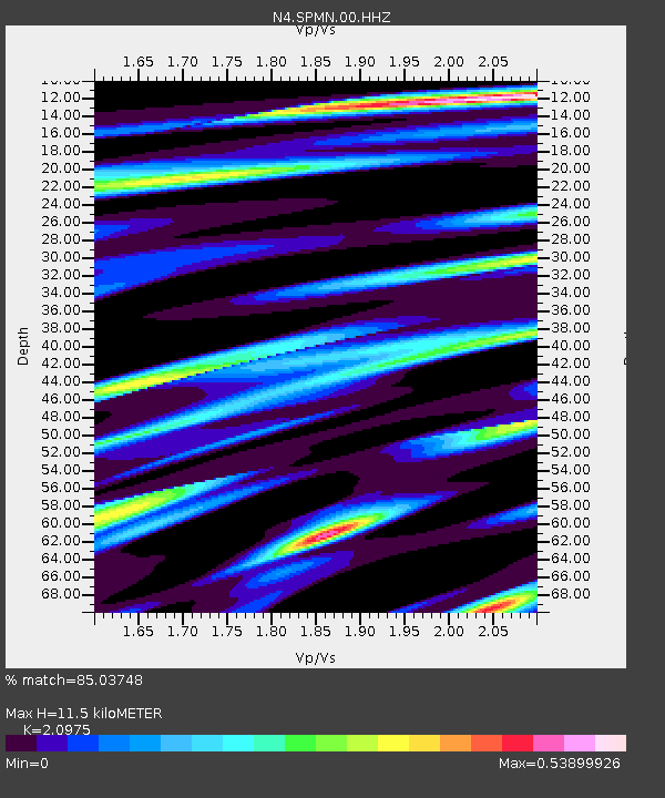
| Estimated Moho Depth: |
11.5 km |
| Estimated Crust Vp/Vs: |
2.10 |
| Assumed Crust Vp: |
6.571 km/s |
| Estimated Crust Vs: |
3.133 km/s |
| Estimated Crust Poisson's Ratio: |
0.35 |
|
| Radial Match: |
85.03748 % |
| Radial Bump: |
369 |
| Transverse Match: |
72.215866 % |
| Transverse Bump: |
400 |
| SOD ConfigId: |
22732711 |
| Insert Time: |
2020-10-02 22:01:01.947 +0000 |
| GWidth: |
2.5 |
| Max Bumps: |
400 |
| Tol: |
0.001 |
|

Signal To Noise
| Channel | StoN | STA | LTA |
| N4:SPMN:00:HHZ:20200918T21:54:55.428998Z | 3.6517172 | 9.1657233E-7 | 2.5099763E-7 |
| N4:SPMN:00:HH1:20200918T21:54:55.428998Z | 0.9839727 | 1.9771599E-7 | 2.0093646E-7 |
| N4:SPMN:00:HH2:20200918T21:54:55.428998Z | 1.6284275 | 4.6880973E-7 | 2.8789108E-7 |
| Arrivals |
| Ps | 2.0 SECOND |
| PpPs | 5.3 SECOND |
| PsPs/PpSs | 7.2 SECOND |


