You are here: Home > Network List > O2 - Oklahoma Consolidated Temporary Seismic Networks Stations List
> Station DRIP Dripping spring state park, Oklahoma, USA > Earthquake Result Viewer
DRIP Dripping spring state park, Oklahoma, USA - Earthquake Result Viewer
| Earthquake location: |
Central Mid-Atlantic Ridge |
| Earthquake latitude/longitude: |
1.0/-26.8 |
| Earthquake time(UTC): |
2020/09/18 (262) 21:43:59 GMT |
| Earthquake Depth: |
10 km |
| Earthquake Magnitude: |
6.9 Mww |
| Earthquake Catalog/Contributor: |
NEIC PDE/us |
|
| Network: |
O2 Oklahoma Consolidated Temporary Seismic Networks |
| Station: |
DRIP Dripping spring state park, Oklahoma, USA |
| Lat/Lon: |
35.61 N/96.07 W |
| Elevation: |
243 m |
|
| Distance: |
72.6 deg |
| Az: |
307.034 deg |
| Baz: |
101.604 deg |
| Ray Param: |
0.053546086 |
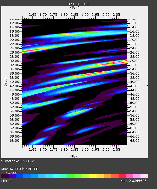
| Estimated Moho Depth: |
30.0 km |
| Estimated Crust Vp/Vs: |
2.09 |
| Assumed Crust Vp: |
6.426 km/s |
| Estimated Crust Vs: |
3.075 km/s |
| Estimated Crust Poisson's Ratio: |
0.35 |
|
| Radial Match: |
91.91452 % |
| Radial Bump: |
377 |
| Transverse Match: |
76.974556 % |
| Transverse Bump: |
400 |
| SOD ConfigId: |
22732711 |
| Insert Time: |
2020-10-02 22:03:32.601 +0000 |
| GWidth: |
2.5 |
| Max Bumps: |
400 |
| Tol: |
0.001 |
|

Signal To Noise
| Channel | StoN | STA | LTA |
| O2:DRIP: :HHZ:20200918T21:54:55.770001Z | 6.5428176 | 1.4496152E-6 | 2.2155824E-7 |
| O2:DRIP: :HHN:20200918T21:54:55.770001Z | 0.7878223 | 1.6100257E-7 | 2.0436407E-7 |
| O2:DRIP: :HHE:20200918T21:54:55.770001Z | 1.8862276 | 3.9447488E-7 | 2.0913429E-7 |
| Arrivals |
| Ps | 5.2 SECOND |
| PpPs | 14 SECOND |
| PsPs/PpSs | 19 SECOND |


