You are here: Home > Network List > O2 - Oklahoma Consolidated Temporary Seismic Networks Stations List
> Station FREE Freedom, Oklahoma, USA > Earthquake Result Viewer
FREE Freedom, Oklahoma, USA - Earthquake Result Viewer
| Earthquake location: |
Central Mid-Atlantic Ridge |
| Earthquake latitude/longitude: |
1.0/-26.8 |
| Earthquake time(UTC): |
2020/09/18 (262) 21:43:59 GMT |
| Earthquake Depth: |
10 km |
| Earthquake Magnitude: |
6.9 Mww |
| Earthquake Catalog/Contributor: |
NEIC PDE/us |
|
| Network: |
O2 Oklahoma Consolidated Temporary Seismic Networks |
| Station: |
FREE Freedom, Oklahoma, USA |
| Lat/Lon: |
36.93 N/99.27 W |
| Elevation: |
563 m |
|
| Distance: |
75.4 deg |
| Az: |
307.873 deg |
| Baz: |
99.946 deg |
| Ray Param: |
0.05168713 |
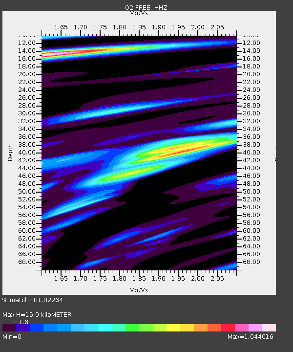
| Estimated Moho Depth: |
15.0 km |
| Estimated Crust Vp/Vs: |
1.60 |
| Assumed Crust Vp: |
6.426 km/s |
| Estimated Crust Vs: |
4.016 km/s |
| Estimated Crust Poisson's Ratio: |
0.18 |
|
| Radial Match: |
81.82264 % |
| Radial Bump: |
400 |
| Transverse Match: |
40.62109 % |
| Transverse Bump: |
400 |
| SOD ConfigId: |
22732711 |
| Insert Time: |
2020-10-02 22:03:38.068 +0000 |
| GWidth: |
2.5 |
| Max Bumps: |
400 |
| Tol: |
0.001 |
|

Signal To Noise
| Channel | StoN | STA | LTA |
| O2:FREE: :HHZ:20200918T21:55:12.04997Z | 3.2895093 | 8.503729E-7 | 2.5851057E-7 |
| O2:FREE: :HHN:20200918T21:55:12.04997Z | 1.3236374 | 3.9299766E-7 | 2.9690736E-7 |
| O2:FREE: :HHE:20200918T21:55:12.04997Z | 1.12409 | 3.0516844E-7 | 2.7148045E-7 |
| Arrivals |
| Ps | 1.5 SECOND |
| PpPs | 5.9 SECOND |
| PsPs/PpSs | 7.3 SECOND |


