You are here: Home > Network List > O2 - Oklahoma Consolidated Temporary Seismic Networks Stations List
> Station FW03 Mooreland, Oklahoma, USA > Earthquake Result Viewer
FW03 Mooreland, Oklahoma, USA - Earthquake Result Viewer
| Earthquake location: |
Central Mid-Atlantic Ridge |
| Earthquake latitude/longitude: |
1.0/-26.8 |
| Earthquake time(UTC): |
2020/09/18 (262) 21:43:59 GMT |
| Earthquake Depth: |
10 km |
| Earthquake Magnitude: |
6.9 Mww |
| Earthquake Catalog/Contributor: |
NEIC PDE/us |
|
| Network: |
O2 Oklahoma Consolidated Temporary Seismic Networks |
| Station: |
FW03 Mooreland, Oklahoma, USA |
| Lat/Lon: |
36.53 N/99.17 W |
| Elevation: |
628 m |
|
| Distance: |
75.3 deg |
| Az: |
307.478 deg |
| Baz: |
99.904 deg |
| Ray Param: |
0.051779915 |
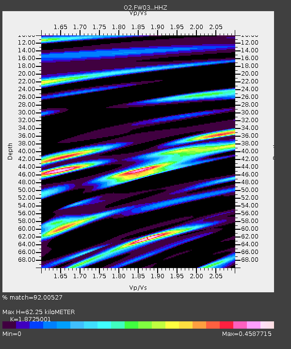
| Estimated Moho Depth: |
62.25 km |
| Estimated Crust Vp/Vs: |
1.87 |
| Assumed Crust Vp: |
6.426 km/s |
| Estimated Crust Vs: |
3.432 km/s |
| Estimated Crust Poisson's Ratio: |
0.30 |
|
| Radial Match: |
92.00527 % |
| Radial Bump: |
400 |
| Transverse Match: |
62.0482 % |
| Transverse Bump: |
400 |
| SOD ConfigId: |
22732711 |
| Insert Time: |
2020-10-02 22:03:41.211 +0000 |
| GWidth: |
2.5 |
| Max Bumps: |
400 |
| Tol: |
0.001 |
|

Signal To Noise
| Channel | StoN | STA | LTA |
| O2:FW03: :HHZ:20200918T21:55:11.204999Z | 2.2295206 | 7.264646E-7 | 3.2583893E-7 |
| O2:FW03: :HHN:20200918T21:55:11.204999Z | 0.6843988 | 2.8243517E-7 | 4.1267631E-7 |
| O2:FW03: :HHE:20200918T21:55:11.204999Z | 1.6474636 | 4.8131636E-7 | 2.92156E-7 |
| Arrivals |
| Ps | 8.7 SECOND |
| PpPs | 27 SECOND |
| PsPs/PpSs | 36 SECOND |


