You are here: Home > Network List > O2 - Oklahoma Consolidated Temporary Seismic Networks Stations List
> Station FW05 Cleo Springs, Oklahoma, USA > Earthquake Result Viewer
FW05 Cleo Springs, Oklahoma, USA - Earthquake Result Viewer
| Earthquake location: |
Central Mid-Atlantic Ridge |
| Earthquake latitude/longitude: |
1.0/-26.8 |
| Earthquake time(UTC): |
2020/09/18 (262) 21:43:59 GMT |
| Earthquake Depth: |
10 km |
| Earthquake Magnitude: |
6.9 Mww |
| Earthquake Catalog/Contributor: |
NEIC PDE/us |
|
| Network: |
O2 Oklahoma Consolidated Temporary Seismic Networks |
| Station: |
FW05 Cleo Springs, Oklahoma, USA |
| Lat/Lon: |
36.47 N/98.61 W |
| Elevation: |
444 m |
|
| Distance: |
74.8 deg |
| Az: |
307.503 deg |
| Baz: |
100.247 deg |
| Ray Param: |
0.052084636 |
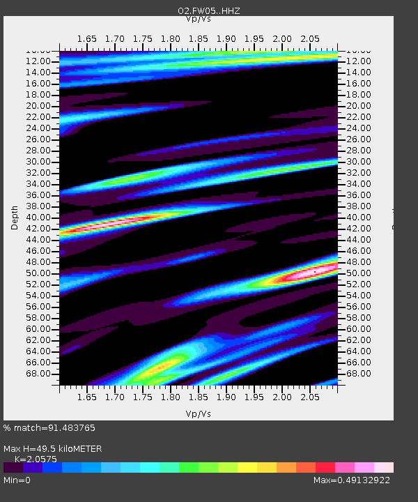
| Estimated Moho Depth: |
49.5 km |
| Estimated Crust Vp/Vs: |
2.06 |
| Assumed Crust Vp: |
6.426 km/s |
| Estimated Crust Vs: |
3.123 km/s |
| Estimated Crust Poisson's Ratio: |
0.35 |
|
| Radial Match: |
91.483765 % |
| Radial Bump: |
279 |
| Transverse Match: |
86.460045 % |
| Transverse Bump: |
322 |
| SOD ConfigId: |
22732711 |
| Insert Time: |
2020-10-02 22:03:43.615 +0000 |
| GWidth: |
2.5 |
| Max Bumps: |
400 |
| Tol: |
0.001 |
|

Signal To Noise
| Channel | StoN | STA | LTA |
| O2:FW05: :HHZ:20200918T21:55:08.559979Z | 4.717969 | 1.9085492E-6 | 4.0452773E-7 |
| O2:FW05: :HHN:20200918T21:55:08.559979Z | 0.74771696 | 4.1065076E-7 | 5.4920616E-7 |
| O2:FW05: :HHE:20200918T21:55:08.559979Z | 1.1948813 | 8.022655E-7 | 6.7141855E-7 |
| Arrivals |
| Ps | 8.4 SECOND |
| PpPs | 23 SECOND |
| PsPs/PpSs | 31 SECOND |


