You are here: Home > Network List > O2 - Oklahoma Consolidated Temporary Seismic Networks Stations List
> Station GORE Near Medford, Oklahoma, USA > Earthquake Result Viewer
GORE Near Medford, Oklahoma, USA - Earthquake Result Viewer
| Earthquake location: |
Central Mid-Atlantic Ridge |
| Earthquake latitude/longitude: |
1.0/-26.8 |
| Earthquake time(UTC): |
2020/09/18 (262) 21:43:59 GMT |
| Earthquake Depth: |
10 km |
| Earthquake Magnitude: |
6.9 Mww |
| Earthquake Catalog/Contributor: |
NEIC PDE/us |
|
| Network: |
O2 Oklahoma Consolidated Temporary Seismic Networks |
| Station: |
GORE Near Medford, Oklahoma, USA |
| Lat/Lon: |
36.79 N/97.95 W |
| Elevation: |
348 m |
|
| Distance: |
74.4 deg |
| Az: |
307.924 deg |
| Baz: |
100.75 deg |
| Ray Param: |
0.052404888 |
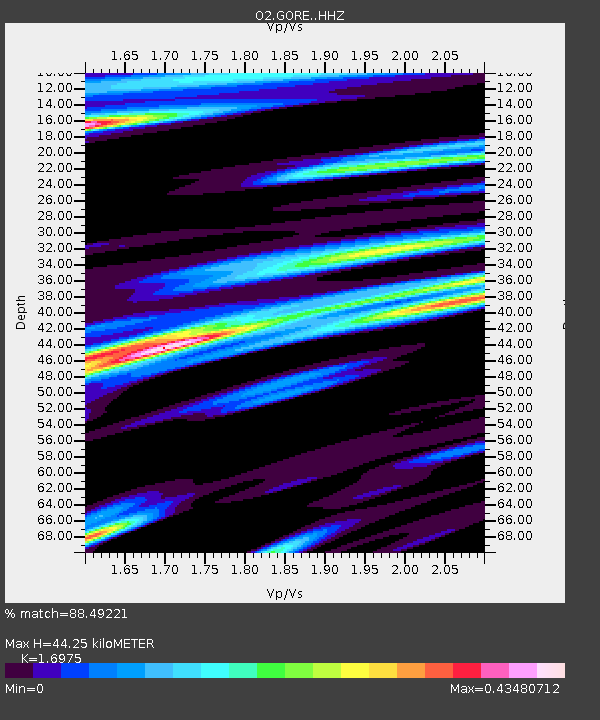
| Estimated Moho Depth: |
44.25 km |
| Estimated Crust Vp/Vs: |
1.70 |
| Assumed Crust Vp: |
6.483 km/s |
| Estimated Crust Vs: |
3.819 km/s |
| Estimated Crust Poisson's Ratio: |
0.23 |
|
| Radial Match: |
88.49221 % |
| Radial Bump: |
357 |
| Transverse Match: |
55.516056 % |
| Transverse Bump: |
400 |
| SOD ConfigId: |
22732711 |
| Insert Time: |
2020-10-02 22:03:49.331 +0000 |
| GWidth: |
2.5 |
| Max Bumps: |
400 |
| Tol: |
0.001 |
|

Signal To Noise
| Channel | StoN | STA | LTA |
| O2:GORE: :HHZ:20200918T21:55:05.869977Z | 4.182546 | 1.0880882E-6 | 2.601497E-7 |
| O2:GORE: :HHN:20200918T21:55:05.869977Z | 0.55465543 | 1.2771946E-7 | 2.3026811E-7 |
| O2:GORE: :HHE:20200918T21:55:05.869977Z | 1.1265352 | 2.957092E-7 | 2.624944E-7 |
| Arrivals |
| Ps | 4.9 SECOND |
| PpPs | 18 SECOND |
| PsPs/PpSs | 23 SECOND |


