You are here: Home > Network List > O2 - Oklahoma Consolidated Temporary Seismic Networks Stations List
> Station PW09 Ralston, Oklahoma > Earthquake Result Viewer
PW09 Ralston, Oklahoma - Earthquake Result Viewer
| Earthquake location: |
Central Mid-Atlantic Ridge |
| Earthquake latitude/longitude: |
1.0/-26.8 |
| Earthquake time(UTC): |
2020/09/18 (262) 21:43:59 GMT |
| Earthquake Depth: |
10 km |
| Earthquake Magnitude: |
6.9 Mww |
| Earthquake Catalog/Contributor: |
NEIC PDE/us |
|
| Network: |
O2 Oklahoma Consolidated Temporary Seismic Networks |
| Station: |
PW09 Ralston, Oklahoma |
| Lat/Lon: |
36.45 N/96.82 W |
| Elevation: |
291 m |
|
| Distance: |
73.4 deg |
| Az: |
307.761 deg |
| Baz: |
101.376 deg |
| Ray Param: |
0.0530362 |
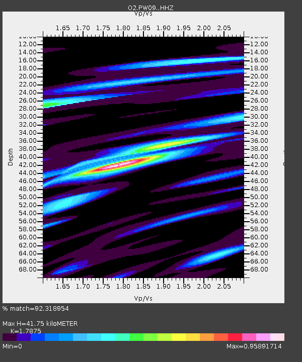
| Estimated Moho Depth: |
41.75 km |
| Estimated Crust Vp/Vs: |
1.79 |
| Assumed Crust Vp: |
6.483 km/s |
| Estimated Crust Vs: |
3.627 km/s |
| Estimated Crust Poisson's Ratio: |
0.27 |
|
| Radial Match: |
92.318954 % |
| Radial Bump: |
328 |
| Transverse Match: |
75.38351 % |
| Transverse Bump: |
398 |
| SOD ConfigId: |
22732711 |
| Insert Time: |
2020-10-02 22:04:04.343 +0000 |
| GWidth: |
2.5 |
| Max Bumps: |
400 |
| Tol: |
0.001 |
|

Signal To Noise
| Channel | StoN | STA | LTA |
| O2:PW09: :HHZ:20200918T21:55:00.280011Z | 5.6267376 | 1.1380408E-6 | 2.0225589E-7 |
| O2:PW09: :HHN:20200918T21:55:00.280011Z | 0.9864369 | 2.7379212E-7 | 2.7755664E-7 |
| O2:PW09: :HHE:20200918T21:55:00.280011Z | 3.0975661 | 4.874292E-7 | 1.5735877E-7 |
| Arrivals |
| Ps | 5.2 SECOND |
| PpPs | 17 SECOND |
| PsPs/PpSs | 23 SECOND |


