You are here: Home > Network List > O2 - Oklahoma Consolidated Temporary Seismic Networks Stations List
> Station PW19 Marland, Oklahoma, USA > Earthquake Result Viewer
PW19 Marland, Oklahoma, USA - Earthquake Result Viewer
| Earthquake location: |
Central Mid-Atlantic Ridge |
| Earthquake latitude/longitude: |
1.0/-26.8 |
| Earthquake time(UTC): |
2020/09/18 (262) 21:43:59 GMT |
| Earthquake Depth: |
10 km |
| Earthquake Magnitude: |
6.9 Mww |
| Earthquake Catalog/Contributor: |
NEIC PDE/us |
|
| Network: |
O2 Oklahoma Consolidated Temporary Seismic Networks |
| Station: |
PW19 Marland, Oklahoma, USA |
| Lat/Lon: |
36.57 N/97.04 W |
| Elevation: |
301 m |
|
| Distance: |
73.6 deg |
| Az: |
307.848 deg |
| Baz: |
101.271 deg |
| Ray Param: |
0.052904807 |
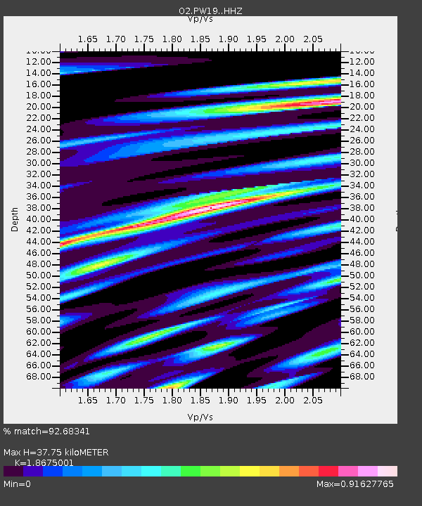
| Estimated Moho Depth: |
37.75 km |
| Estimated Crust Vp/Vs: |
1.87 |
| Assumed Crust Vp: |
6.483 km/s |
| Estimated Crust Vs: |
3.471 km/s |
| Estimated Crust Poisson's Ratio: |
0.30 |
|
| Radial Match: |
92.68341 % |
| Radial Bump: |
400 |
| Transverse Match: |
70.28756 % |
| Transverse Bump: |
400 |
| SOD ConfigId: |
22732711 |
| Insert Time: |
2020-10-02 22:04:13.213 +0000 |
| GWidth: |
2.5 |
| Max Bumps: |
400 |
| Tol: |
0.001 |
|

Signal To Noise
| Channel | StoN | STA | LTA |
| O2:PW19: :HHZ:20200918T21:55:01.439984Z | 3.6617048 | 1.1316085E-6 | 3.0903874E-7 |
| O2:PW19: :HHN:20200918T21:55:01.439984Z | 0.91355735 | 2.780871E-7 | 3.0440026E-7 |
| O2:PW19: :HHE:20200918T21:55:01.439984Z | 2.9615567 | 6.0160414E-7 | 2.0313782E-7 |
| Arrivals |
| Ps | 5.2 SECOND |
| PpPs | 16 SECOND |
| PsPs/PpSs | 21 SECOND |


