You are here: Home > Network List > OK - Oklahoma Seismic Network Stations List
> Station MOOR Moore, Oklahoma, USA > Earthquake Result Viewer
MOOR Moore, Oklahoma, USA - Earthquake Result Viewer
| Earthquake location: |
Central Mid-Atlantic Ridge |
| Earthquake latitude/longitude: |
1.0/-26.8 |
| Earthquake time(UTC): |
2020/09/18 (262) 21:43:59 GMT |
| Earthquake Depth: |
10 km |
| Earthquake Magnitude: |
6.9 Mww |
| Earthquake Catalog/Contributor: |
NEIC PDE/us |
|
| Network: |
OK Oklahoma Seismic Network |
| Station: |
MOOR Moore, Oklahoma, USA |
| Lat/Lon: |
35.34 N/97.66 W |
| Elevation: |
371 m |
|
| Distance: |
73.9 deg |
| Az: |
306.496 deg |
| Baz: |
100.527 deg |
| Ray Param: |
0.052735552 |
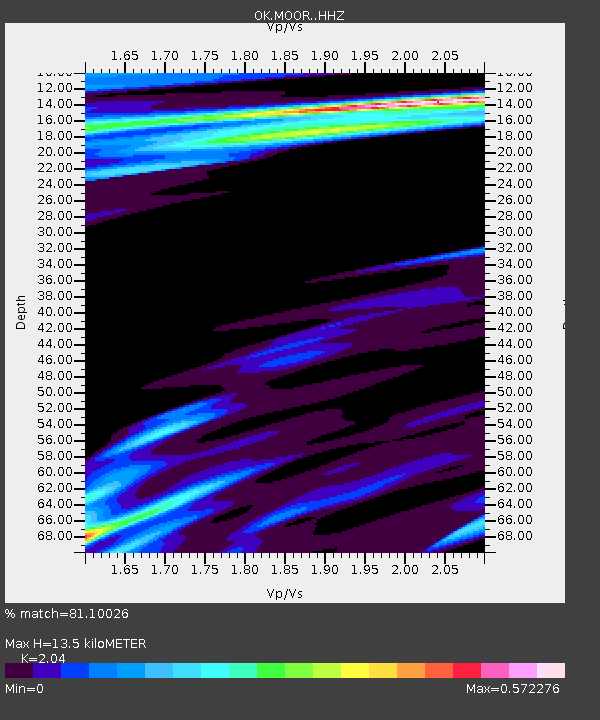
| Estimated Moho Depth: |
13.5 km |
| Estimated Crust Vp/Vs: |
2.04 |
| Assumed Crust Vp: |
6.426 km/s |
| Estimated Crust Vs: |
3.15 km/s |
| Estimated Crust Poisson's Ratio: |
0.34 |
|
| Radial Match: |
81.10026 % |
| Radial Bump: |
400 |
| Transverse Match: |
69.534615 % |
| Transverse Bump: |
400 |
| SOD ConfigId: |
22732711 |
| Insert Time: |
2020-10-02 22:05:15.736 +0000 |
| GWidth: |
2.5 |
| Max Bumps: |
400 |
| Tol: |
0.001 |
|

Signal To Noise
| Channel | StoN | STA | LTA |
| OK:MOOR: :HHZ:20200918T21:55:02.985028Z | 3.7283876 | 1.4589973E-6 | 3.9132124E-7 |
| OK:MOOR: :HHN:20200918T21:55:02.985028Z | 1.8518112 | 6.404765E-7 | 3.4586492E-7 |
| OK:MOOR: :HHE:20200918T21:55:02.985028Z | 1.3109946 | 8.1585887E-7 | 6.2232056E-7 |
| Arrivals |
| Ps | 2.2 SECOND |
| PpPs | 6.2 SECOND |
| PsPs/PpSs | 8.5 SECOND |


