You are here: Home > Network List > TX - Texas Seismological Network Stations List
> Station HNDO Hondo > Earthquake Result Viewer
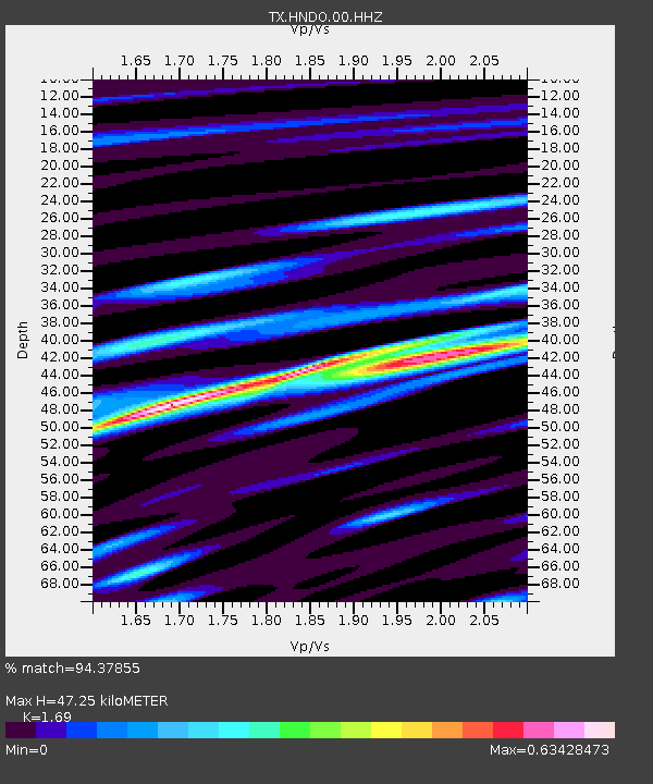
HNDO Hondo - Earthquake Result Viewer
| Earthquake location: |
Central Mid-Atlantic Ridge |
| Earthquake latitude/longitude: |
1.0/-26.8 |
| Earthquake time(UTC): |
2020/09/18 (262) 21:43:59 GMT |
| Earthquake Depth: |
10 km |
| Earthquake Magnitude: |
6.9 Mww |
| Earthquake Catalog/Contributor: |
NEIC PDE/us |
|
| Network: |
TX Texas Seismological Network |
| Station: |
HNDO Hondo |
| Lat/Lon: |
29.53 N/99.28 W |
| Elevation: |
381 m |
|
| Distance: |
74.3 deg |
| Az: |
300.318 deg |
| Baz: |
97.963 deg |
| Ray Param: |
0.052453905 |
| Estimated Moho Depth: |
47.25 km |
| Estimated Crust Vp/Vs: |
1.69 |
| Assumed Crust Vp: |
6.347 km/s |
| Estimated Crust Vs: |
3.756 km/s |
| Estimated Crust Poisson's Ratio: |
0.23 |
|
| Radial Match: |
94.37855 % |
| Radial Bump: |
400 |
| Transverse Match: |
86.12715 % |
| Transverse Bump: |
400 |
| SOD ConfigId: |
22732711 |
| Insert Time: |
2020-10-02 22:09:27.050 +0000 |
| GWidth: |
2.5 |
| Max Bumps: |
400 |
| Tol: |
0.001 |
|

Signal To Noise
| Channel | StoN | STA | LTA |
| TX:HNDO:00:HHZ:20200918T21:55:05.454999Z | 7.826839 | 7.691881E-7 | 9.8275706E-8 |
| TX:HNDO:00:HH1:20200918T21:55:05.454999Z | 2.0703769 | 2.2621488E-7 | 1.09262665E-7 |
| TX:HNDO:00:HH2:20200918T21:55:05.454999Z | 2.7007554 | 3.1183777E-7 | 1.1546316E-7 |
| Arrivals |
| Ps | 5.3 SECOND |
| PpPs | 19 SECOND |
| PsPs/PpSs | 25 SECOND |


