You are here: Home > Network List > WI - West Indies IPGP Network Stations List
> Station MAGL Barre de l'ile, Marie-Galante, Guadeloupe > Earthquake Result Viewer
MAGL Barre de l'ile, Marie-Galante, Guadeloupe - Earthquake Result Viewer
| Earthquake location: |
Central Mid-Atlantic Ridge |
| Earthquake latitude/longitude: |
1.0/-26.8 |
| Earthquake time(UTC): |
2020/09/18 (262) 21:43:59 GMT |
| Earthquake Depth: |
10 km |
| Earthquake Magnitude: |
6.9 Mww |
| Earthquake Catalog/Contributor: |
NEIC PDE/us |
|
| Network: |
WI West Indies IPGP Network |
| Station: |
MAGL Barre de l'ile, Marie-Galante, Guadeloupe |
| Lat/Lon: |
15.95 N/61.28 W |
| Elevation: |
159 m |
|
| Distance: |
37.1 deg |
| Az: |
295.524 deg |
| Baz: |
110.294 deg |
| Ray Param: |
0.07634871 |
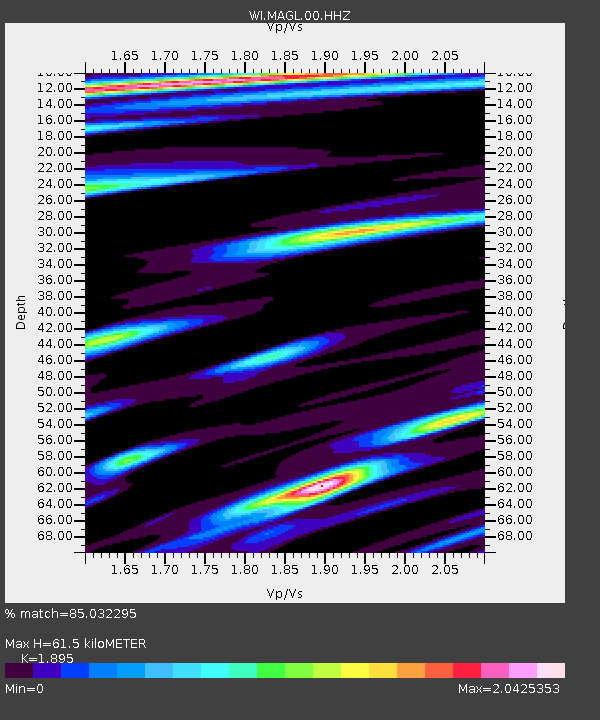
| Estimated Moho Depth: |
61.5 km |
| Estimated Crust Vp/Vs: |
1.89 |
| Assumed Crust Vp: |
5.88 km/s |
| Estimated Crust Vs: |
3.103 km/s |
| Estimated Crust Poisson's Ratio: |
0.31 |
|
| Radial Match: |
85.032295 % |
| Radial Bump: |
367 |
| Transverse Match: |
70.8315 % |
| Transverse Bump: |
396 |
| SOD ConfigId: |
22732711 |
| Insert Time: |
2020-10-02 22:13:59.825 +0000 |
| GWidth: |
2.5 |
| Max Bumps: |
400 |
| Tol: |
0.001 |
|
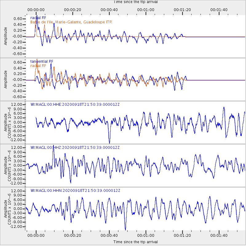
Signal To Noise
| Channel | StoN | STA | LTA |
| WI:MAGL:00:HHZ:20200918T21:50:39.000012Z | 3.1039658 | 3.0486708E-6 | 9.821857E-7 |
| WI:MAGL:00:HHN:20200918T21:50:39.000012Z | 0.9316458 | 1.9531215E-6 | 2.0964205E-6 |
| WI:MAGL:00:HHE:20200918T21:50:39.000012Z | 0.9273016 | 1.8599549E-6 | 2.0057712E-6 |
| Arrivals |
| Ps | 9.9 SECOND |
| PpPs | 29 SECOND |
| PsPs/PpSs | 39 SECOND |


