You are here: Home > Network List > WI - West Indies IPGP Network Stations List
> Station MPOM Morne Pois, Sainte-Anne, Martinique > Earthquake Result Viewer
MPOM Morne Pois, Sainte-Anne, Martinique - Earthquake Result Viewer
| Earthquake location: |
Central Mid-Atlantic Ridge |
| Earthquake latitude/longitude: |
1.0/-26.8 |
| Earthquake time(UTC): |
2020/09/18 (262) 21:43:59 GMT |
| Earthquake Depth: |
10 km |
| Earthquake Magnitude: |
6.9 Mww |
| Earthquake Catalog/Contributor: |
NEIC PDE/us |
|
| Network: |
WI West Indies IPGP Network |
| Station: |
MPOM Morne Pois, Sainte-Anne, Martinique |
| Lat/Lon: |
14.45 N/60.86 W |
| Elevation: |
50 m |
|
| Distance: |
36.2 deg |
| Az: |
293.394 deg |
| Baz: |
108.694 deg |
| Ray Param: |
0.07683713 |
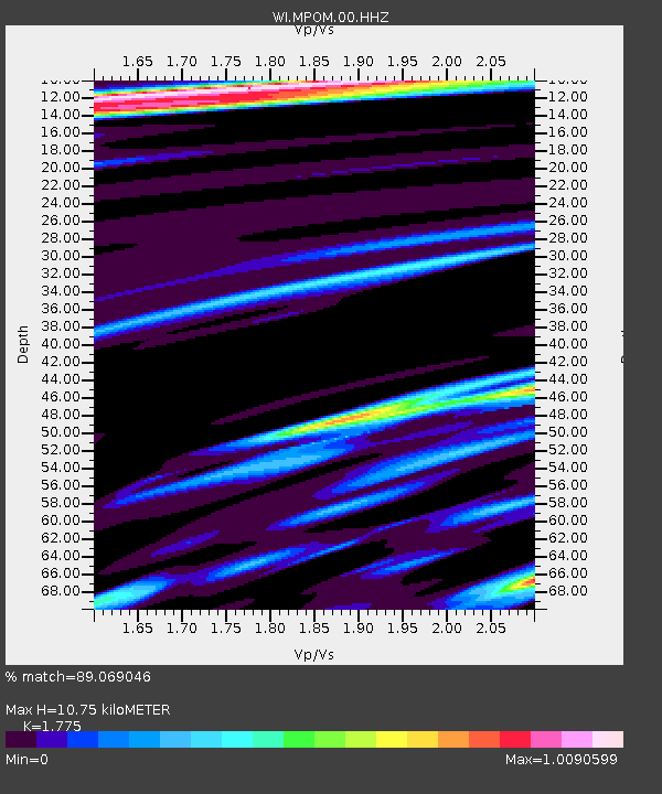
| Estimated Moho Depth: |
10.75 km |
| Estimated Crust Vp/Vs: |
1.77 |
| Assumed Crust Vp: |
5.88 km/s |
| Estimated Crust Vs: |
3.313 km/s |
| Estimated Crust Poisson's Ratio: |
0.27 |
|
| Radial Match: |
89.069046 % |
| Radial Bump: |
298 |
| Transverse Match: |
72.15846 % |
| Transverse Bump: |
400 |
| SOD ConfigId: |
22732711 |
| Insert Time: |
2020-10-02 22:14:01.590 +0000 |
| GWidth: |
2.5 |
| Max Bumps: |
400 |
| Tol: |
0.001 |
|

Signal To Noise
| Channel | StoN | STA | LTA |
| WI:MPOM:00:HHZ:20200918T21:50:31.479993Z | 5.158633 | 2.8159359E-6 | 5.458686E-7 |
| WI:MPOM:00:HHN:20200918T21:50:31.479993Z | 1.6139084 | 7.5556864E-7 | 4.6816078E-7 |
| WI:MPOM:00:HHE:20200918T21:50:31.479993Z | 2.586295 | 1.8817605E-6 | 7.275893E-7 |
| Arrivals |
| Ps | 1.5 SECOND |
| PpPs | 4.8 SECOND |
| PsPs/PpSs | 6.3 SECOND |


