You are here: Home > Network List > XT94 - Micronesia Seismic Network Stations List
> Station NAU Nauru > Earthquake Result Viewer
NAU Nauru - Earthquake Result Viewer
| Earthquake location: |
Kuril Islands |
| Earthquake latitude/longitude: |
43.9/147.9 |
| Earthquake time(UTC): |
1994/10/09 (282) 07:55:38 GMT |
| Earthquake Depth: |
23 km |
| Earthquake Magnitude: |
6.5 MB, 7.0 MS, 6.7 UNKNOWN, 7.3 MW |
| Earthquake Catalog/Contributor: |
WHDF/NEIC |
|
| Network: |
XT Micronesia Seismic Network |
| Station: |
NAU Nauru |
| Lat/Lon: |
0.51 S/166.93 E |
| Elevation: |
1.0 m |
|
| Distance: |
47.4 deg |
| Az: |
153.697 deg |
| Baz: |
341.316 deg |
| Ray Param: |
0.07000094 |
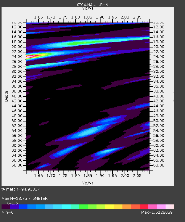
| Estimated Moho Depth: |
23.75 km |
| Estimated Crust Vp/Vs: |
1.60 |
| Assumed Crust Vp: |
5.195 km/s |
| Estimated Crust Vs: |
3.247 km/s |
| Estimated Crust Poisson's Ratio: |
0.18 |
|
| Radial Match: |
94.93837 % |
| Radial Bump: |
301 |
| Transverse Match: |
69.69609 % |
| Transverse Bump: |
400 |
| SOD ConfigId: |
17000 |
| Insert Time: |
2010-03-09 01:24:21.816 +0000 |
| GWidth: |
2.5 |
| Max Bumps: |
400 |
| Tol: |
0.001 |
|

Signal To Noise
| Channel | StoN | STA | LTA |
| XT:NAU: :BHN:19941009T08:03:39.338013Z | 3.274121 | 3.1941897E-6 | 9.755869E-7 |
| XT:NAU: :BHE:19941009T08:03:39.338013Z | 0.3470818 | 5.146767E-7 | 1.4828685E-6 |
| XT:NAU: :BHZ:19941009T08:03:39.338013Z | 5.2516294 | 2.4295182E-6 | 4.6262176E-7 |
| Arrivals |
| Ps | 2.9 SECOND |
| PpPs | 11 SECOND |
| PsPs/PpSs | 14 SECOND |


