You are here: Home > Network List > TA - USArray Transportable Network (new EarthScope stations) Stations List
> Station A22K Sinclair Lake, AK, USA > Earthquake Result Viewer
A22K Sinclair Lake, AK, USA - Earthquake Result Viewer

| Earthquake location: |
Mindanao, Philippines |
| Earthquake latitude/longitude: |
9.2/126.7 |
| Earthquake time(UTC): |
2020/09/20 (264) 22:13:15 GMT |
| Earthquake Depth: |
10 km |
| Earthquake Magnitude: |
5.8 Mww |
| Earthquake Catalog/Contributor: |
NEIC PDE/us |
|
| Network: |
TA USArray Transportable Network (new EarthScope stations) |
| Station: |
A22K Sinclair Lake, AK, USA |
| Lat/Lon: |
71.00 N/154.97 W |
| Elevation: |
6.0 m |
|
| Distance: |
77.5 deg |
| Az: |
19.172 deg |
| Baz: |
261.926 deg |
| Ray Param: |
0.050269917 |
| Estimated Moho Depth: |
13.25 km |
| Estimated Crust Vp/Vs: |
1.78 |
| Assumed Crust Vp: |
5.782 km/s |
| Estimated Crust Vs: |
3.249 km/s |
| Estimated Crust Poisson's Ratio: |
0.27 |
|
| Radial Match: |
85.733475 % |
| Radial Bump: |
374 |
| Transverse Match: |
69.14041 % |
| Transverse Bump: |
400 |
| SOD ConfigId: |
22732711 |
| Insert Time: |
2020-10-04 22:23:21.292 +0000 |
| GWidth: |
2.5 |
| Max Bumps: |
400 |
| Tol: |
0.001 |
|
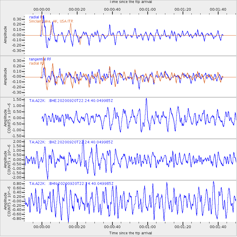
Signal To Noise
| Channel | StoN | STA | LTA |
| TA:A22K: :BHZ:20200920T22:24:40.049985Z | 3.0101535 | 9.085973E-7 | 3.0184418E-7 |
| TA:A22K: :BHN:20200920T22:24:40.049985Z | 1.0339706 | 2.88509E-7 | 2.790302E-7 |
| TA:A22K: :BHE:20200920T22:24:40.049985Z | 1.4986932 | 3.5541208E-7 | 2.3714799E-7 |
| Arrivals |
| Ps | 1.8 SECOND |
| PpPs | 6.2 SECOND |
| PsPs/PpSs | 8.0 SECOND |


