You are here: Home > Network List > TA - USArray Transportable Network (new EarthScope stations) Stations List
> Station D25K Kavik River, AK, USA > Earthquake Result Viewer
D25K Kavik River, AK, USA - Earthquake Result Viewer
| Earthquake location: |
Mindanao, Philippines |
| Earthquake latitude/longitude: |
9.2/126.7 |
| Earthquake time(UTC): |
2020/09/20 (264) 22:13:15 GMT |
| Earthquake Depth: |
10 km |
| Earthquake Magnitude: |
5.8 Mww |
| Earthquake Catalog/Contributor: |
NEIC PDE/us |
|
| Network: |
TA USArray Transportable Network (new EarthScope stations) |
| Station: |
D25K Kavik River, AK, USA |
| Lat/Lon: |
69.32 N/146.38 W |
| Elevation: |
770 m |
|
| Distance: |
80.3 deg |
| Az: |
21.086 deg |
| Baz: |
270.379 deg |
| Ray Param: |
0.04834692 |
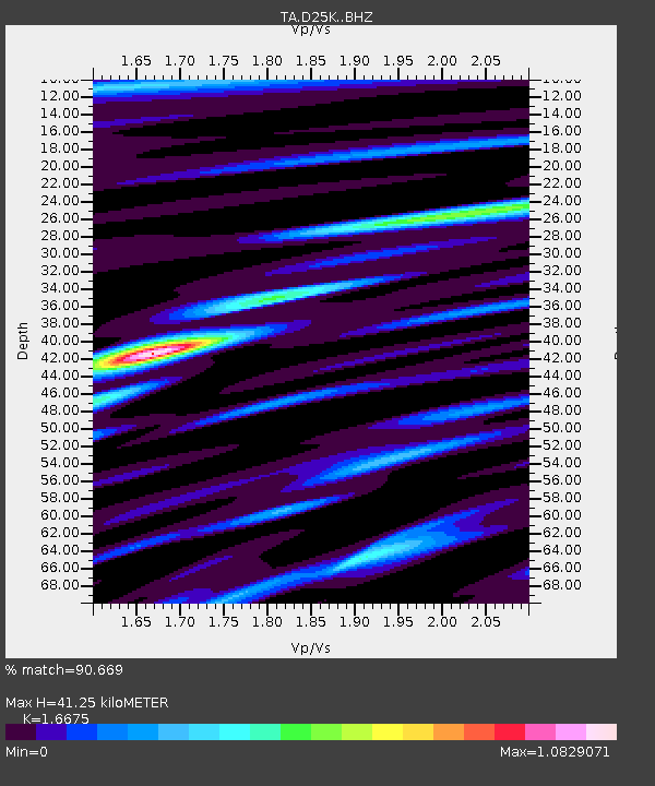
| Estimated Moho Depth: |
41.25 km |
| Estimated Crust Vp/Vs: |
1.67 |
| Assumed Crust Vp: |
6.378 km/s |
| Estimated Crust Vs: |
3.825 km/s |
| Estimated Crust Poisson's Ratio: |
0.22 |
|
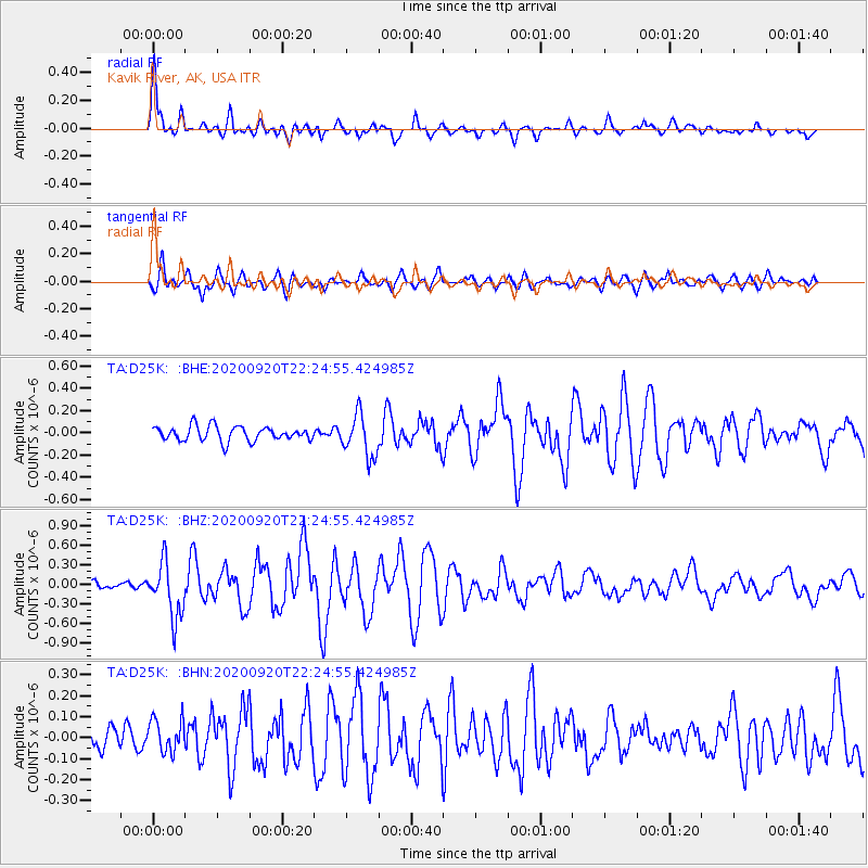
| Radial Match: |
90.669 % |
| Radial Bump: |
400 |
| Transverse Match: |
70.674675 % |
| Transverse Bump: |
400 |
| SOD ConfigId: |
22732711 |
| Insert Time: |
2020-10-04 22:23:44.342 +0000 |
| GWidth: |
2.5 |
| Max Bumps: |
400 |
| Tol: |
0.001 |
|
Signal To Noise
| Channel | StoN | STA | LTA |
| TA:D25K: :BHZ:20200920T22:24:55.424985Z | 5.2350388 | 4.158611E-7 | 7.9438024E-8 |
| TA:D25K: :BHN:20200920T22:24:55.424985Z | 1.3399748 | 7.919838E-8 | 5.910438E-8 |
| TA:D25K: :BHE:20200920T22:24:55.424985Z | 2.869856 | 1.8775496E-7 | 6.542313E-8 |
| Arrivals |
| Ps | 4.4 SECOND |
| PpPs | 17 SECOND |
| PsPs/PpSs | 21 SECOND |


