You are here: Home > Network List > IU - Global Seismograph Network (GSN - IRIS/USGS) Stations List
> Station PMG Port Moresby, New Guinea > Earthquake Result Viewer
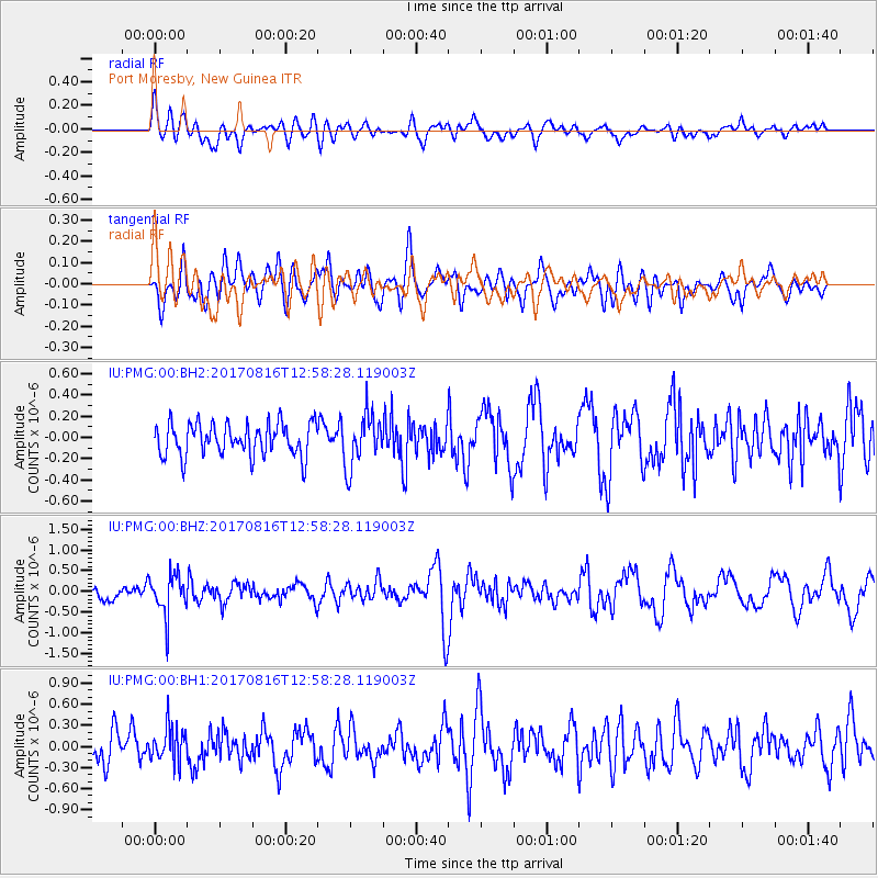
PMG Port Moresby, New Guinea - Earthquake Result Viewer
*The percent match for this event was below the threshold and hence no stack was calculated.
| Earthquake location: |
Northwest Of Ryukyu Islands |
| Earthquake latitude/longitude: |
28.6/127.9 |
| Earthquake time(UTC): |
2017/08/16 (228) 12:51:25 GMT |
| Earthquake Depth: |
197 km |
| Earthquake Magnitude: |
5.7 Mww |
| Earthquake Catalog/Contributor: |
NEIC PDE/us |
|
| Network: |
IU Global Seismograph Network (GSN - IRIS/USGS) |
| Station: |
PMG Port Moresby, New Guinea |
| Lat/Lon: |
9.40 S/147.16 E |
| Elevation: |
90 m |
|
| Distance: |
42.1 deg |
| Az: |
151.023 deg |
| Baz: |
334.435 deg |
| Ray Param: |
$rayparam |
*The percent match for this event was below the threshold and hence was not used in the summary stack. |
|
| Radial Match: |
45.031364 % |
| Radial Bump: |
400 |
| Transverse Match: |
65.30361 % |
| Transverse Bump: |
400 |
| SOD ConfigId: |
2140511 |
| Insert Time: |
2017-08-30 04:50:06.255 +0000 |
| GWidth: |
2.5 |
| Max Bumps: |
400 |
| Tol: |
0.001 |
|
Signal To Noise
| Channel | StoN | STA | LTA |
| IU:PMG:00:BHZ:20170816T12:58:28.119003Z | 2.7815342 | 4.835669E-7 | 1.7384899E-7 |
| IU:PMG:00:BH1:20170816T12:58:28.119003Z | 1.1792303 | 2.5009922E-7 | 2.1208683E-7 |
| IU:PMG:00:BH2:20170816T12:58:28.119003Z | 1.6009198 | 2.4550496E-7 | 1.5335245E-7 |
| Arrivals |
| Ps | |
| PpPs | |
| PsPs/PpSs | |


