You are here: Home > Network List > IW - Intermountain West Stations List
> Station MOOW Moose Ponds, Wyoming, USA > Earthquake Result Viewer
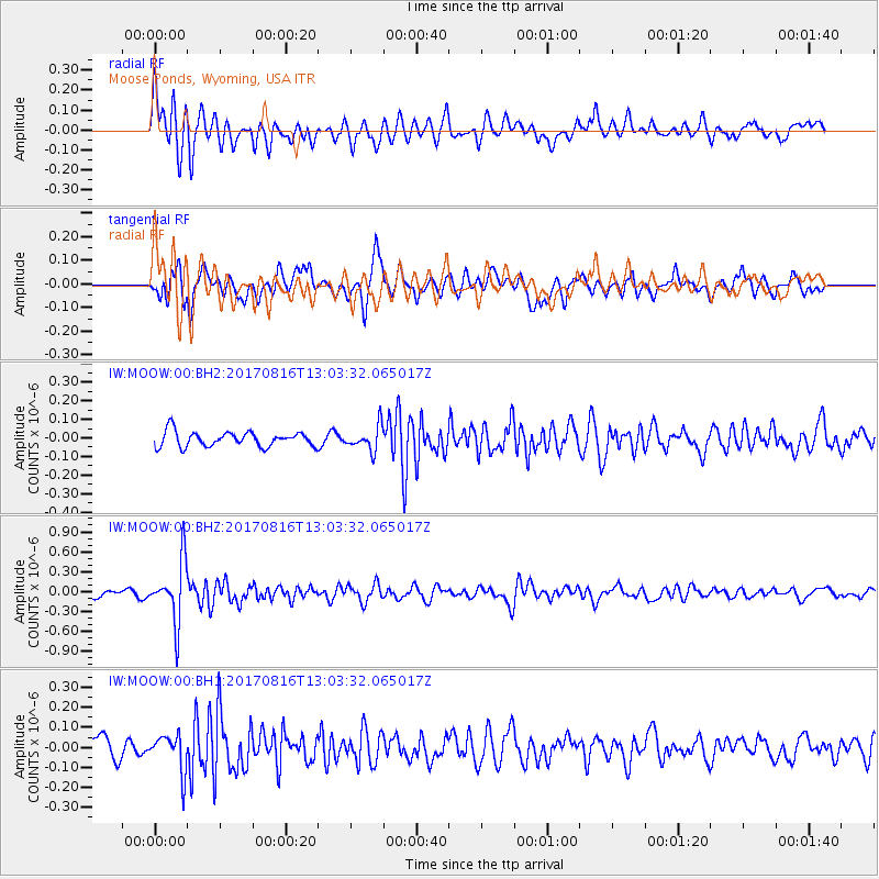
MOOW Moose Ponds, Wyoming, USA - Earthquake Result Viewer
*The percent match for this event was below the threshold and hence no stack was calculated.
| Earthquake location: |
Northwest Of Ryukyu Islands |
| Earthquake latitude/longitude: |
28.6/127.9 |
| Earthquake time(UTC): |
2017/08/16 (228) 12:51:25 GMT |
| Earthquake Depth: |
197 km |
| Earthquake Magnitude: |
5.7 Mww |
| Earthquake Catalog/Contributor: |
NEIC PDE/us |
|
| Network: |
IW Intermountain West |
| Station: |
MOOW Moose Ponds, Wyoming, USA |
| Lat/Lon: |
43.75 N/110.74 W |
| Elevation: |
2128 m |
|
| Distance: |
90.1 deg |
| Az: |
38.245 deg |
| Baz: |
311.343 deg |
| Ray Param: |
$rayparam |
*The percent match for this event was below the threshold and hence was not used in the summary stack. |
|
| Radial Match: |
77.589615 % |
| Radial Bump: |
400 |
| Transverse Match: |
72.417046 % |
| Transverse Bump: |
400 |
| SOD ConfigId: |
2140511 |
| Insert Time: |
2017-08-30 04:50:26.637 +0000 |
| GWidth: |
2.5 |
| Max Bumps: |
400 |
| Tol: |
0.001 |
|
Signal To Noise
| Channel | StoN | STA | LTA |
| IW:MOOW:00:BHZ:20170816T13:03:32.065017Z | 7.754554 | 4.535427E-7 | 5.8487274E-8 |
| IW:MOOW:00:BH1:20170816T13:03:32.065017Z | 1.6601903 | 9.2430795E-8 | 5.5674814E-8 |
| IW:MOOW:00:BH2:20170816T13:03:32.065017Z | 1.6540661 | 6.6138426E-8 | 3.9985355E-8 |
| Arrivals |
| Ps | |
| PpPs | |
| PsPs/PpSs | |


