You are here: Home > Network List > TA - USArray Transportable Network (new EarthScope stations) Stations List
> Station TOLK Toolik Lake Research Station, AK, USA > Earthquake Result Viewer
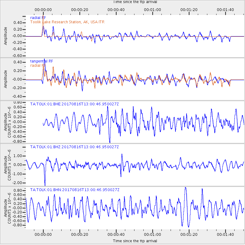
TOLK Toolik Lake Research Station, AK, USA - Earthquake Result Viewer
*The percent match for this event was below the threshold and hence no stack was calculated.
| Earthquake location: |
Northwest Of Ryukyu Islands |
| Earthquake latitude/longitude: |
28.6/127.9 |
| Earthquake time(UTC): |
2017/08/16 (228) 12:51:25 GMT |
| Earthquake Depth: |
197 km |
| Earthquake Magnitude: |
5.7 Mww |
| Earthquake Catalog/Contributor: |
NEIC PDE/us |
|
| Network: |
TA USArray Transportable Network (new EarthScope stations) |
| Station: |
TOLK Toolik Lake Research Station, AK, USA |
| Lat/Lon: |
68.64 N/149.57 W |
| Elevation: |
760 m |
|
| Distance: |
60.9 deg |
| Az: |
24.553 deg |
| Baz: |
274.464 deg |
| Ray Param: |
$rayparam |
*The percent match for this event was below the threshold and hence was not used in the summary stack. |
|
| Radial Match: |
51.66507 % |
| Radial Bump: |
400 |
| Transverse Match: |
49.515312 % |
| Transverse Bump: |
400 |
| SOD ConfigId: |
2140511 |
| Insert Time: |
2017-08-30 04:51:19.590 +0000 |
| GWidth: |
2.5 |
| Max Bumps: |
400 |
| Tol: |
0.001 |
|
Signal To Noise
| Channel | StoN | STA | LTA |
| TA:TOLK:01:BHZ:20170816T13:00:46.950027Z | 2.5853035 | 7.3588023E-7 | 2.8463978E-7 |
| TA:TOLK:01:BHN:20170816T13:00:46.950027Z | 0.9007721 | 3.006888E-7 | 3.3381232E-7 |
| TA:TOLK:01:BHE:20170816T13:00:46.950027Z | 0.92409104 | 1.8663111E-7 | 2.0196183E-7 |
| Arrivals |
| Ps | |
| PpPs | |
| PsPs/PpSs | |


