You are here: Home > Network List > TA - USArray Transportable Network (new EarthScope stations) Stations List
> Station POKR Poker Plat Research Range, AK, USA > Earthquake Result Viewer
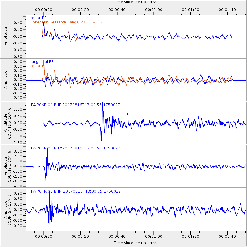
POKR Poker Plat Research Range, AK, USA - Earthquake Result Viewer
*The percent match for this event was below the threshold and hence no stack was calculated.
| Earthquake location: |
Northwest Of Ryukyu Islands |
| Earthquake latitude/longitude: |
28.6/127.9 |
| Earthquake time(UTC): |
2017/08/16 (228) 12:51:25 GMT |
| Earthquake Depth: |
197 km |
| Earthquake Magnitude: |
5.7 Mww |
| Earthquake Catalog/Contributor: |
NEIC PDE/us |
|
| Network: |
TA USArray Transportable Network (new EarthScope stations) |
| Station: |
POKR Poker Plat Research Range, AK, USA |
| Lat/Lon: |
65.12 N/147.43 W |
| Elevation: |
501 m |
|
| Distance: |
62.2 deg |
| Az: |
28.447 deg |
| Baz: |
278.286 deg |
| Ray Param: |
$rayparam |
*The percent match for this event was below the threshold and hence was not used in the summary stack. |
|
| Radial Match: |
79.57044 % |
| Radial Bump: |
400 |
| Transverse Match: |
65.60908 % |
| Transverse Bump: |
400 |
| SOD ConfigId: |
2140511 |
| Insert Time: |
2017-08-30 04:51:19.693 +0000 |
| GWidth: |
2.5 |
| Max Bumps: |
400 |
| Tol: |
0.001 |
|
Signal To Noise
| Channel | StoN | STA | LTA |
| TA:POKR:01:BHZ:20170816T13:00:55.175002Z | 13.195507 | 1.202778E-6 | 9.115057E-8 |
| TA:POKR:01:BHN:20170816T13:00:55.175002Z | 4.2110095 | 3.892109E-7 | 9.242699E-8 |
| TA:POKR:01:BHE:20170816T13:00:55.175002Z | 6.021091 | 5.238043E-7 | 8.699492E-8 |
| Arrivals |
| Ps | |
| PpPs | |
| PsPs/PpSs | |


