You are here: Home > Network List > US - United States National Seismic Network Stations List
> Station OGNE Ogallala, Nebraska, USA > Earthquake Result Viewer
OGNE Ogallala, Nebraska, USA - Earthquake Result Viewer
*The percent match for this event was below the threshold and hence no stack was calculated.
| Earthquake location: |
Northwest Of Ryukyu Islands |
| Earthquake latitude/longitude: |
28.6/127.9 |
| Earthquake time(UTC): |
2017/08/16 (228) 12:51:25 GMT |
| Earthquake Depth: |
197 km |
| Earthquake Magnitude: |
5.7 Mww |
| Earthquake Catalog/Contributor: |
NEIC PDE/us |
|
| Network: |
US United States National Seismic Network |
| Station: |
OGNE Ogallala, Nebraska, USA |
| Lat/Lon: |
40.95 N/102.03 W |
| Elevation: |
1054 m |
|
| Distance: |
96.7 deg |
| Az: |
35.727 deg |
| Baz: |
317.349 deg |
| Ray Param: |
$rayparam |
*The percent match for this event was below the threshold and hence was not used in the summary stack. |
|
| Radial Match: |
48.962246 % |
| Radial Bump: |
400 |
| Transverse Match: |
53.679955 % |
| Transverse Bump: |
400 |
| SOD ConfigId: |
2140511 |
| Insert Time: |
2017-08-30 04:52:02.414 +0000 |
| GWidth: |
2.5 |
| Max Bumps: |
400 |
| Tol: |
0.001 |
|
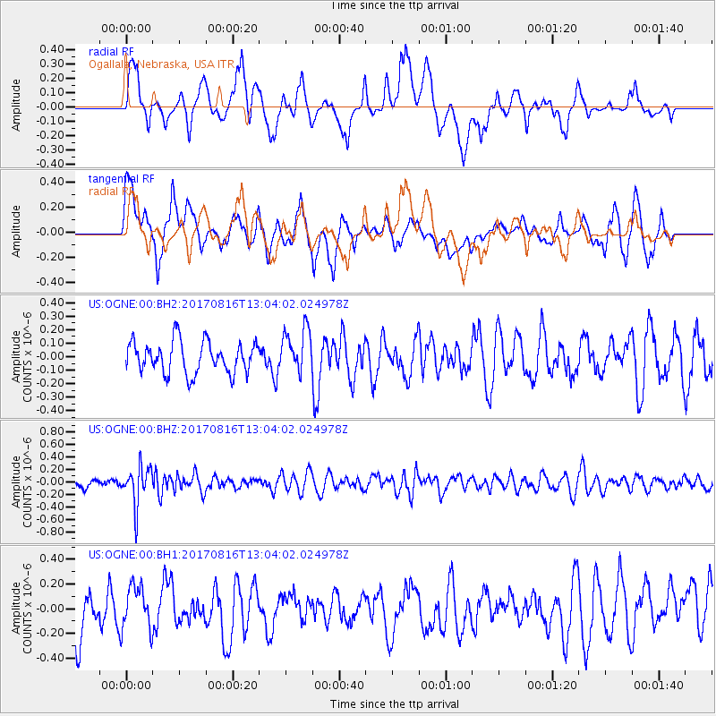
Signal To Noise
| Channel | StoN | STA | LTA |
| US:OGNE:00:BHZ:20170816T13:04:02.024978Z | 3.7280915 | 3.0893338E-7 | 8.2866364E-8 |
| US:OGNE:00:BH1:20170816T13:04:02.024978Z | 0.74825627 | 1.7063586E-7 | 2.2804468E-7 |
| US:OGNE:00:BH2:20170816T13:04:02.024978Z | 1.4120944 | 1.6541512E-7 | 1.1714169E-7 |
| Arrivals |
| Ps | |
| PpPs | |
| PsPs/PpSs | |


